
Christian Abizaid Associate Professor, Department of Geography & Planning and School of the Environment, University of Toronto, Toronto, Canada

Oliver T. Coomes Professor, Department of Geography, McGill University, Montreal, Canada

Yoshito Takasaki Professor, Graduate School of Economics, University of Tokyo, Tokyo, Japan
DOI: 10.21690/foge/2022.65.1f
Media reports from the Brazilian Amazon continue to raise much concern over the fate of the Amazon and its peoples. During the last half century, forests have been cut down or degraded from cattle ranching, illegal logging and mining, roads, agribusiness development, and colonization schemes; fish populations have dwindled, and climate change and dam construction are affecting the hydrology of the Amazon River, threatening biodiversity, the livelihoods of indigenous and folk peoples, and the world's climate (Ferrante and Fearnside 2020; Nobre and Nobre 2020; Walker 2021). Yet, one third of the Amazon is found in neighboring countries, mainly to the west, where formative tributaries like the Ucayali, Marañón, and Napo rivers in Peru descend from the Andes into the Amazon lowlands, bringing the waters that drive flooding, carry sediments, and enable long-distance fish migrations (Junk et al. 2007; Latrubesse et al. 2017; Anderson et al. 2018). Although not isolated from the complex forces shaping dynamics in Brazil, the situation in western Amazonia is less well known.
To gain a perspective on how the region is changing, we undertook a 1000 km trip down the Ucayali River between the cities of Pucallpa and Iquitos in Peru. Each of us has been conducting research on indigenous and folk peoples' (ribereños) livelihoods in the Peruvian Amazon for the past 20-30 years and we have been collaborating closely for nearly a decade on a large-scale study on rural livelihoods and poverty in the region, known as the Peruvian Amazon Rural Livelihoods and Poverty (PARLAP) project. With our experience as a backdrop, we situate our observations from this long distance transect and discuss ongoing developments reshaping rural life and livelihoods that portend more significant transformations to come to western Amazonia.
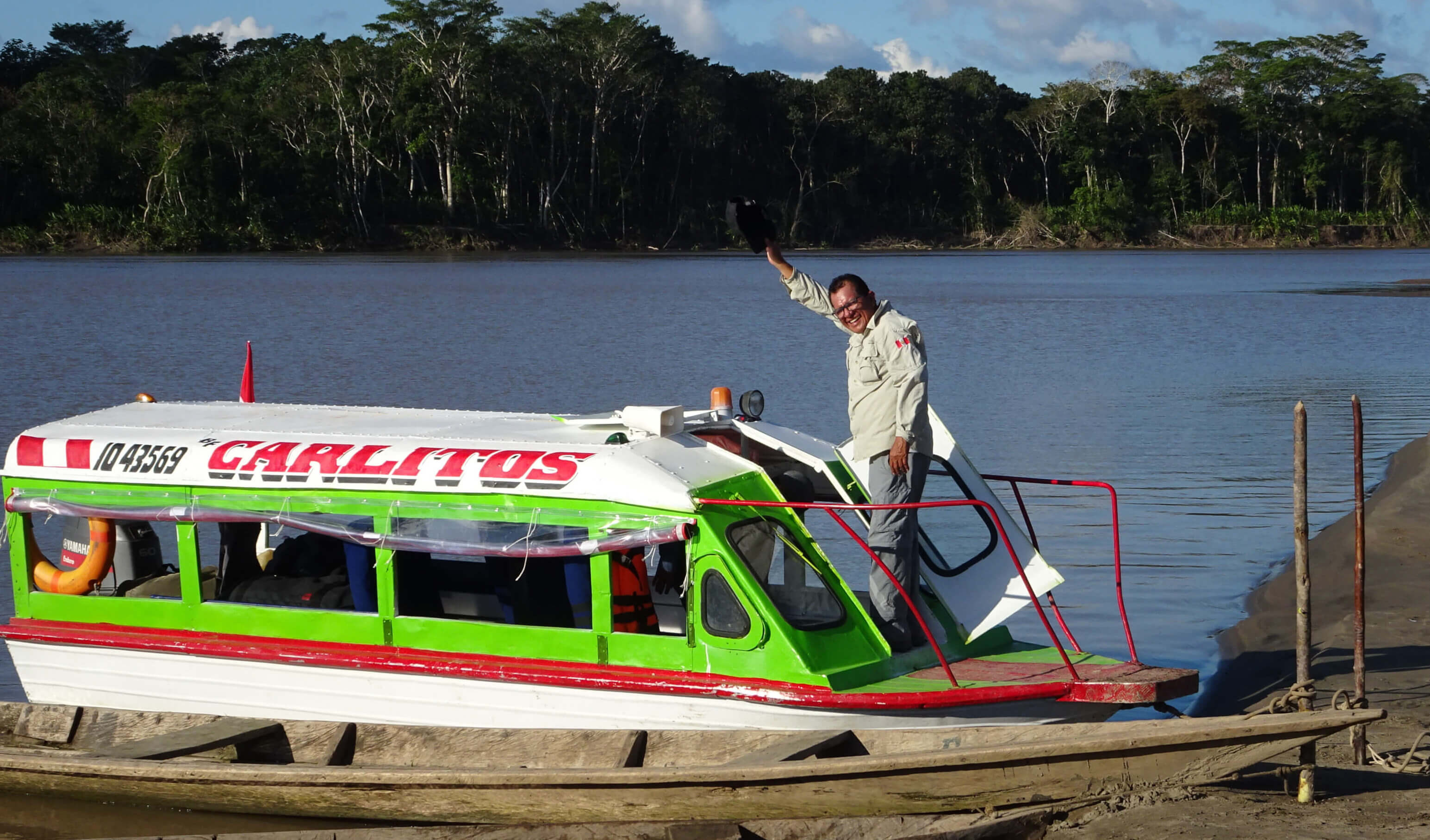
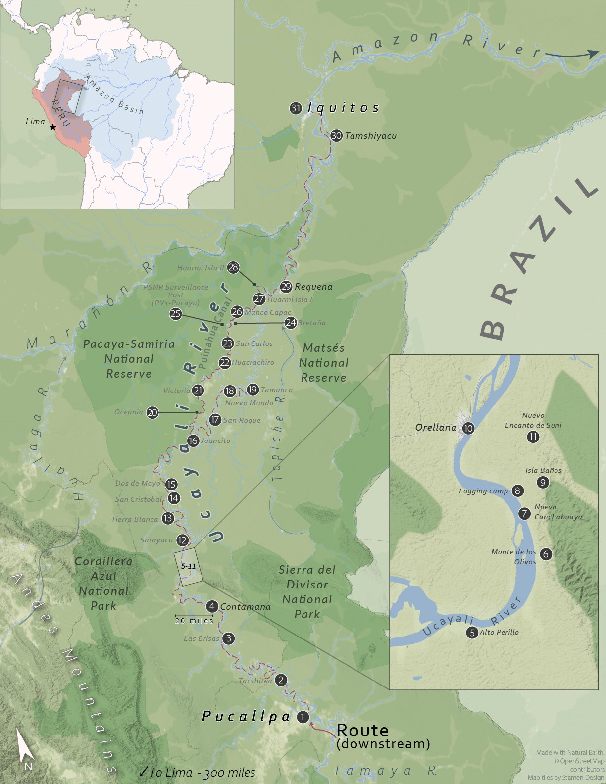
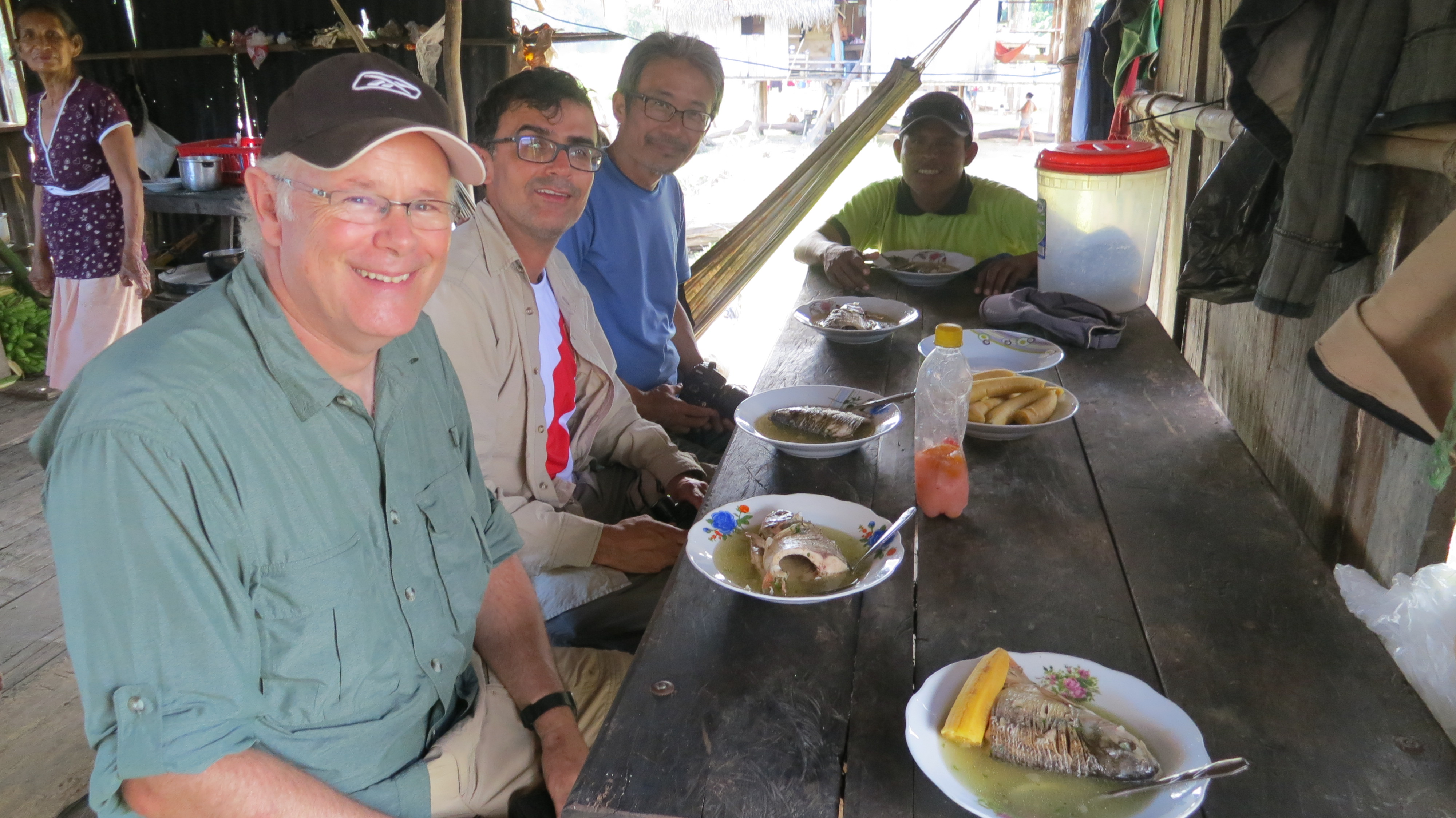
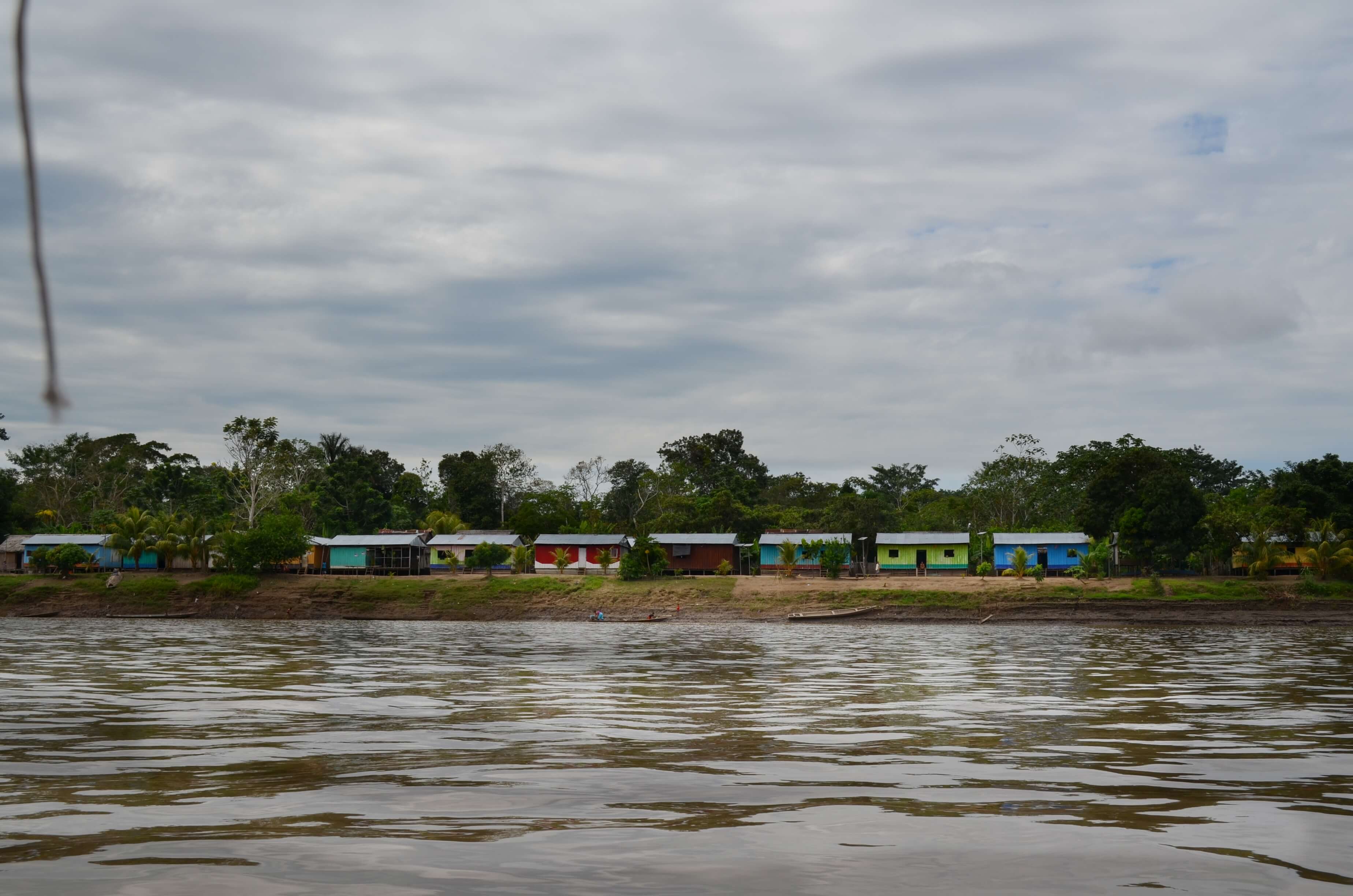
On June 12, 2018, a couple of days prior to the beginning of the FIFA World Cup in Russia, we embarked on the Carlitos (Figure 1) in Pucallpa and over the span of 12 days, we descended the Ucayali northward to the city of Iquitos on the Amazon River (Figure 2). Pucallpa and Iquitos are less than 550 km apart, as the crow flies, yet the distance by boat is greater than 1000 km because of the sinuously meandering course of the Ucayali (Abizaid 2005; Schwenk et al. 2017)(Figure 3). Following in the footsteps of 19th century explorers like William Herndon, Paul Marcoy and Antonio Raimondi, we sought to gain a regional perspective. We visited settlements previously identified from community histories compiled during our PARLAP survey and pulled-in at sites along the way where something interesting caught our eye. Our stops included important towns, such as Contamana, Orellana and Requena, which were originally established as Franciscan missions; we also stopped at smaller towns and riverine communities, fishing camps and logging posts. At each stop, we visited local markets, agricultural fields, fishing grounds and other areas of interest, and talked to people to inform our observations. By the time we reached Iquitos on June 22, just before the San Juan festivities—the most important regional celebration in the Peruvian Amazon— we had visited some 30 different sites (Figure 2), providing us with unique perspective on how this understudied region is changing.
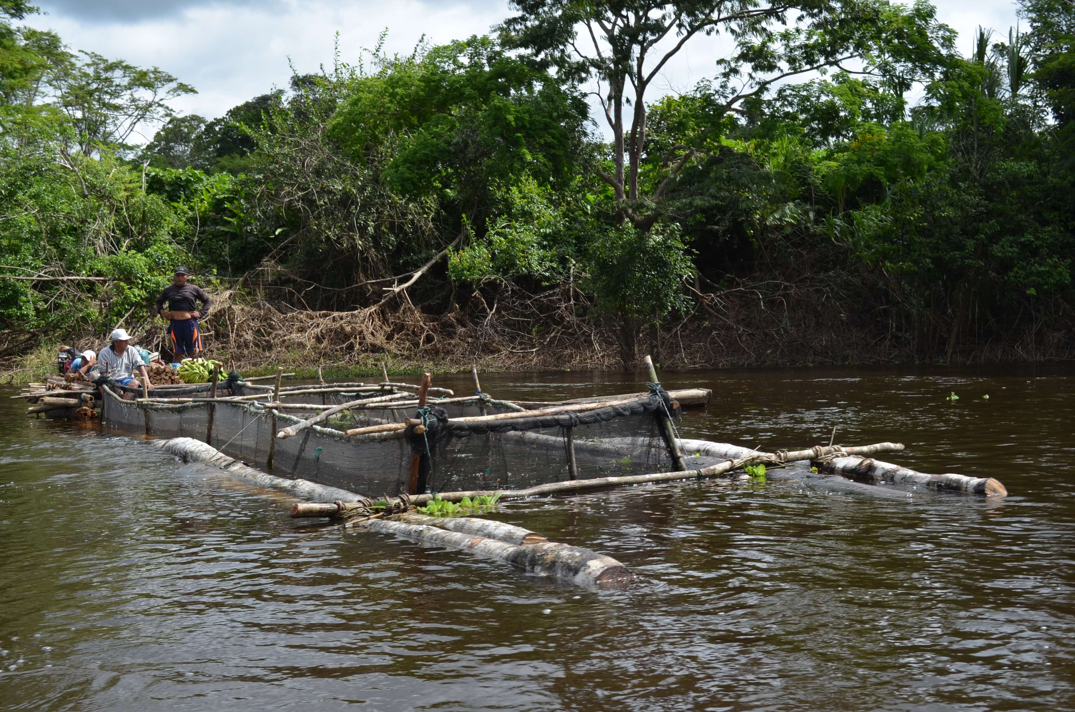
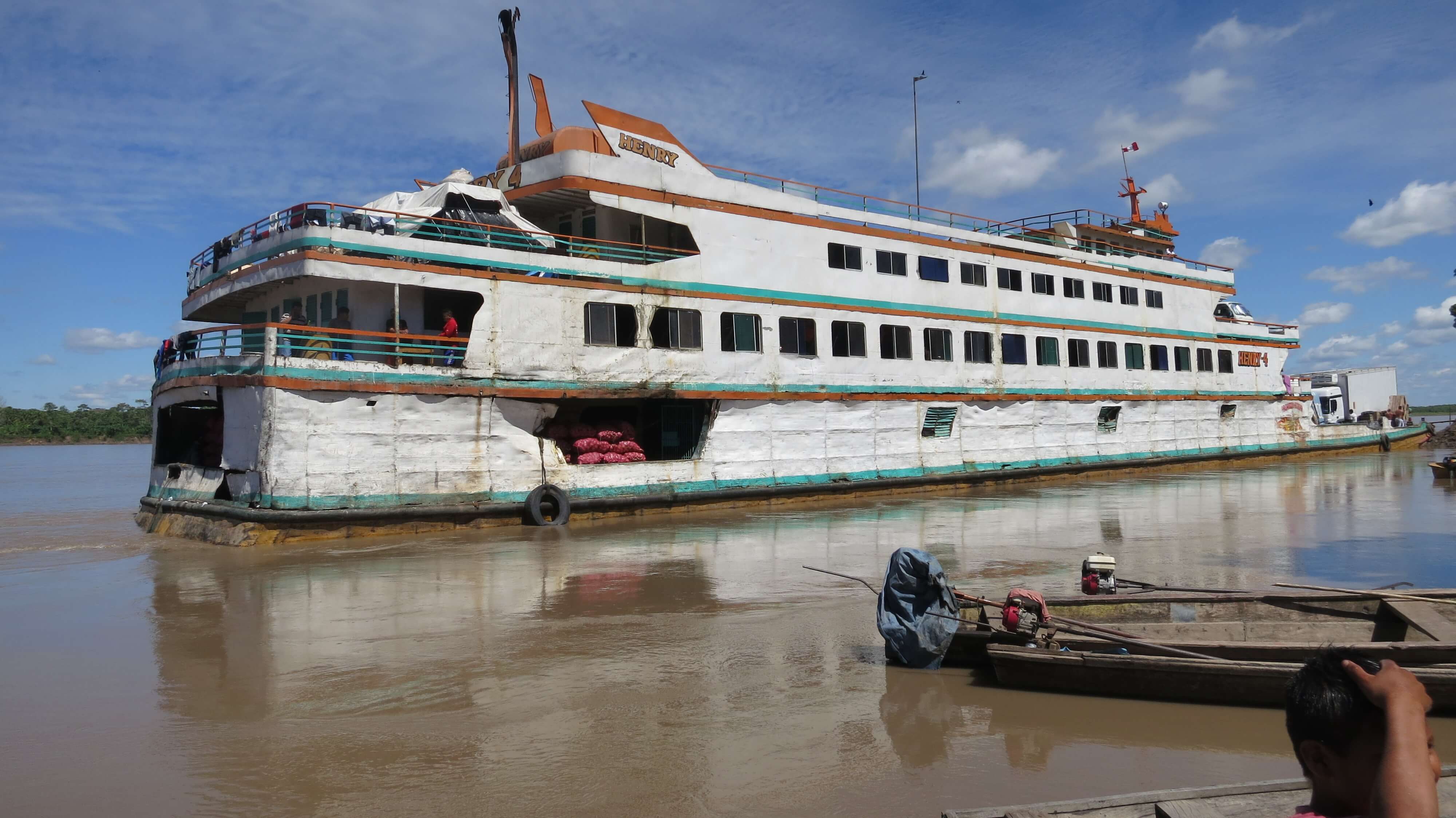
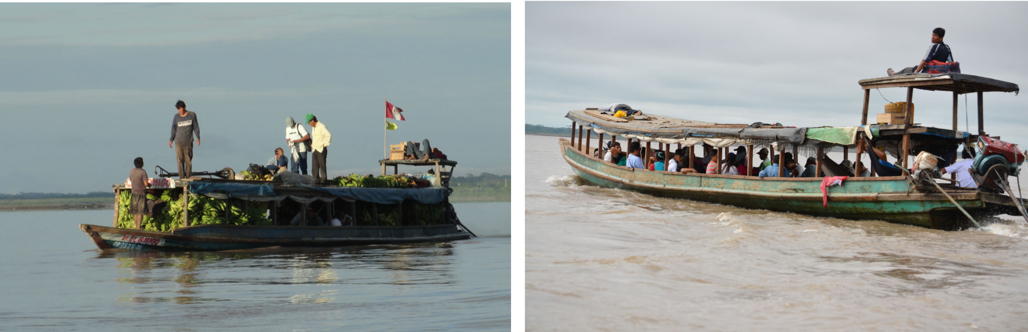
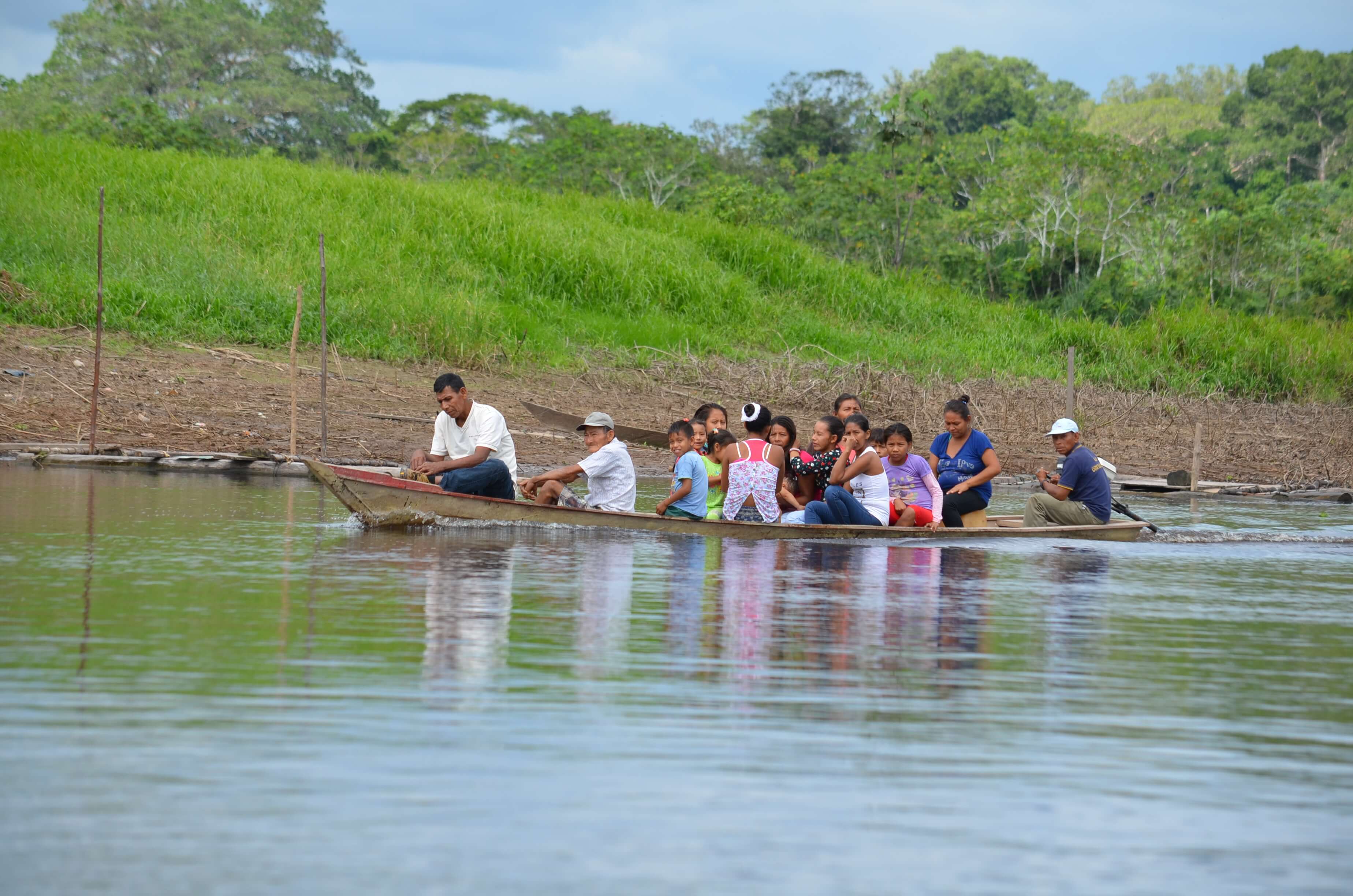
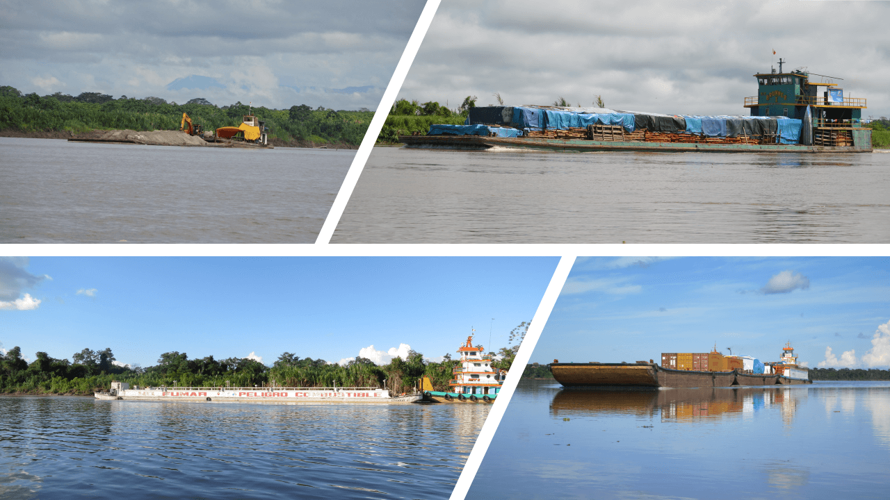
Amazonian rivers have always functioned as natural highways. People have used canoes and rafts since prehistory (Lathrap 1973) but by the mid-19th century, steamships began to transit up and down the Amazon. By the 1950s, diesel engine boats displaced the steamers. Today, a full gamut of watercraft navigates the Ucayali (Salonen et al. 2012). Canoes are still used for local travel in some places and the occasional raft can be seen drifting downriver with logs, durable goods, or live fish (Figure 4). Large lanchas offer regular passenger and cargo service between Pucallpa and Iquitos, stopping in selected towns and communities along the way, many of which function as intermediary hubs between the cities and other rural communities (Figure 5). Smaller boats privately-operated as river buses (colectivos) are more common within a day's travel from the cities; they stop anywhere en route upon request (Figure 6).
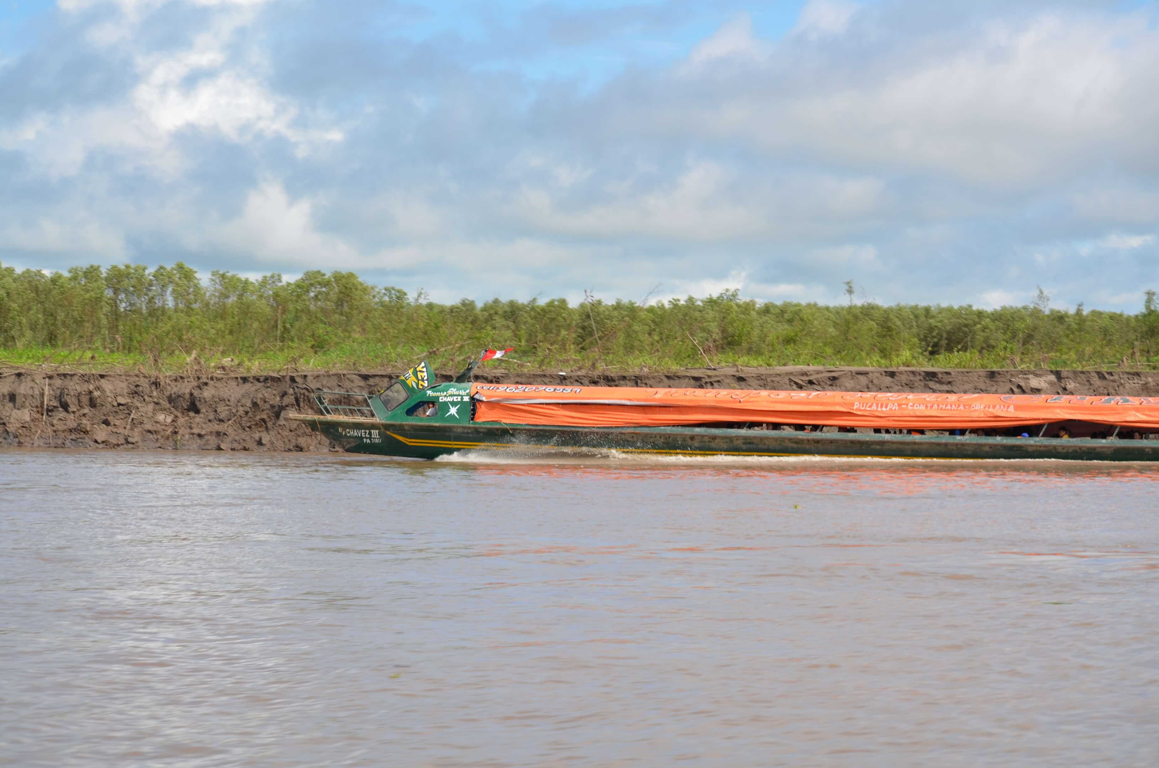
Peque-peques, personal boats powered by a small air-cooled engine--similar to those on a gas-powered lawnmower-- attached to a long shaft and a small propeller have become commonplace (Figure 7). In the last decade, powerful speedboats, known as rápidos, have begun offering regular passenger service with few stops between cities and larger towns within a 10-hour trip, i.e., Atayala, Contamana, Orellana (from Pucallpa); Requena and Nauta (from Iquitos) (Figure 8). Travel is about 3-4 times faster and more comfortable than on a lancha or colectivo but the cost is prohibitive for most people; rápidos run along the main rivers only.
For many, improved river access and transportation are creating new livelihood opportunities, however, access in the region remains spatially and socially uneven (Webster et al. 2016), as the COVID-19 pandemic has come to show (Takasaki et al. 2021). People in towns and communities in peri-urban areas have a wider range of options to travel or transport produce, and to do so more frequently and affordably. In contrast, travel and mobility for people in remote communities, especially those on tributaries that penetrate deep into the upland forests, are constrained by the lack of regular boat service, limited navigability during the low water season, large distances and high sinuosity of rivers, and by availability and cost of fuel. A trip from Saweto, an Asháninka indigenous community on the Upper Tamaya near the border with Brazil, about 160 km (Euclidean) from Pucallpa, takes up to three full days and a fare costs about 90 S/. (about three days wage). In contrast, a trip from a community at a similar distance on the Upper Ucayali only takes 26 hours and the fare is less than half. Even along the main rivers, travel times increase by about 25 percent during the low water season (Tenkanen et al. 2015), as the river becomes shallow and side channels dry up; boat operators must be vigilant to avoid hitting sandbanks or submerged logs. In many riverine communities, people face considerable difficulties getting in and out as the vast floodplain empties when water levels drop, leaving them stranded inland. We witnessed this at Nuevo Encanto de Suni, across from Orellana, where it took us more than an hour by foot to reach the community from the river's edge.
For residents along the Lower Ucayali, changes in river transportation will have more profound implications in the future if Hidrovía Amazónica goes ahead. As part of the controversial Integration of Infrastructure of South America Initiative (IIRSA) (Walker et al. 2019), in 2017 the Peruvian Government approved this 20 year-concession to maintain a permanent navigable channel for large vessels (Figure 9) along the Huallaga, Marañón, Ucayali and Amazonas rivers to a Chinese consortium (Neyra 2020); it is anticipated that 22 km of the Ucayali would be dredged. The mega-project was clearly on people's minds as we passed through. While taking us to a nearby lake, local authorities from Victoria reported that people in the region, mainly Kukama Kukamiria indigenous people, were deeply concerned that the planned dredging will negatively affect fish, which are critical to their livelihoods and culture, and were thus organizing to resist. Indigenous organizations, environmental groups, and the Catholic church have repeatedly called for the cancellation of the mega-project, arguing that the social and environmental impacts would be significant, that local consultation was questionable, and that the project's financial viability is uncertain (Berjón and Cadenas 2018; La República 2020). Environmental Impact Assessments (EIA) have corroborated such claims (La República 2020), and Hidrovía remained stalled. Still, the project has not been totally abandoned. In fact, the Ministry of Transportation recently extended the concession to 23 years and approved an increase in the number of reaches to be dredged. Hidrovía is included in Peru's 2019 National Infrastructure Plan for Competitiveness.
Unlike in Brazil, roads in Peru have barely made their way into the Amazon lowlands, but they are beginning to encroach. Peru's National Road Map from 2017 shows roads stopping at Yurimaguas and Tarapoto, not quite reaching the lowlands in Loreto and Ucayali, except for the Lima-Pucallpa road. There are some departmental roads, but they are rare. Loreto, roughly the size of Guatemala, Nicaragua and Honduras combined, has only two asphalted roads (~200 km) (Arima 2016), and Iquitos is the largest city in the world without a national road connection.
Governments suggest that roads bring development to frontier regions by improving market access, creating jobs, raising incomes, and building of schools, health clinics and other state facilities. Historically, however, roads in tropical forests have also led to deforestation, and often brought crime, dispossession, and marginalization. Arguably, Pucallpas rapid growth and rise as a regional economic center is due largely to its road connection to Lima, but the road has also caused significant forest loss fueled by colonization, cattle ranching, coca, and more recently, oil palm (Loker 1993; Smith et al. 1999; Salisbury and Fagan 2011; Porro et al. 2015; Glinskis and Gutiérrez-Vélez 2019).
Although we travelled by river, roads still emerged as an important theme in our journey. Between Contamana and Dos de Mayo there are two overland passages (varaderos) that have served as trading routes between the Andes and the Amazon since Incan times (Raimondi 1859; Coomes et al. 2020) and according to local residents, today traffickers use them to transport drugs from the Huallaga, through the Ucayali and into Brazil. The strategic importance of the area led the Franciscans to establish a Mission at Sarayacu in the 19th century, where they congregated indigenous peoples (Myers 1990). Ironically, Sarayacu today is a community where traffickers gather to drink, and as we found out, strangers are not welcome.
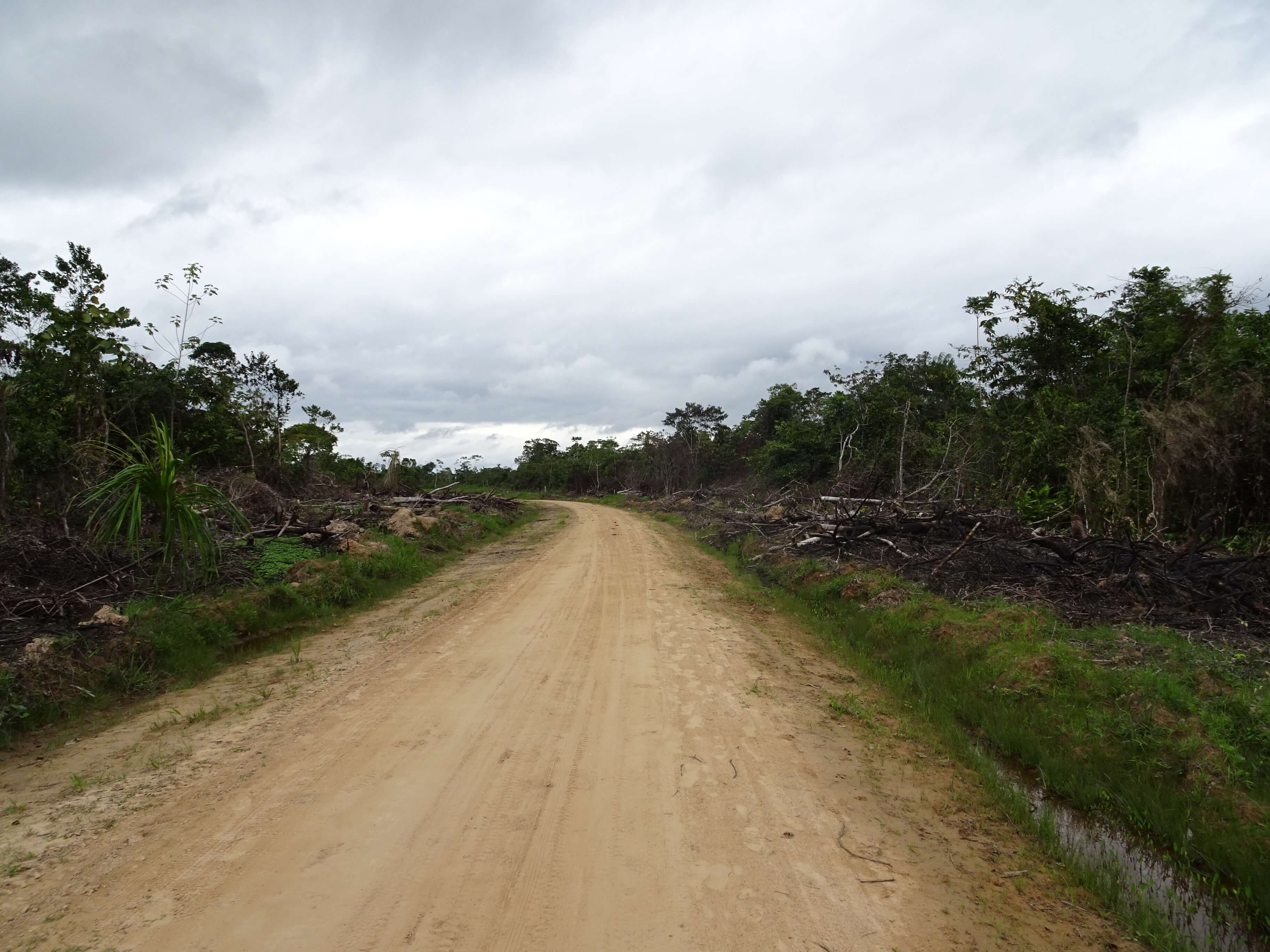
A couple of dirt roads, presumably built by loggers, are already creeping westwards behind Orellana and Tierra Blanca, seeking to connect the Ucayali with towns on the Huallaga River (Finer and Novoa 2015). The road from Tierra Blanca runs parallel to one of the old varaderos, the journey taking three hours by motorcycle (Figure 10) (La Región 2016); the other, has been included in the road plans by the Ministry of Transportation and Communications and was declared of public interest by the Transport Commission of the Peruvian Congress in 2017 (MTC 2005; Proyecto de Ley 203-2016). Informal reports suggest that a larger network of roads exists, which connects to the Huallaga from various communities along a 180 km stretch between Tiruntán and Dos de Mayo on the Ucayali (M. Pinedo-Vasquez pers comm). With roads often come colonists, but we were not expecting that the first people we would see as we arrived at Tierra Blanca would be a group of Mennonites – until recently, Mennonites had not yet reached Peru. They were standing by the river's edge, waiting for a lancha, while everyone else was gathering at a couple of stores to watch Peru's first match in a World Cup in 36 years. The two Mennonite men we talked with explained that they had recently left Bolivia due to problems with Evo Morales' government and land scarcity; another group had migrated from Belize. They originally settled along the Pachitea River, near La Honoria in 2015 but were flooded out. They established three Mennonite colonies, Österreich, Vanderland and Providencia (roughly 500 people), inland from Tierra Blanca. When we asked the Mennonite men if they felt soils there were good for agriculture, they confidently replied that they had been raised in the jungle and knew how to work the land. Standing beside a pile of new tin sheets for the roof of their houses, they informed us that they were producing typical Amazonian crops (plantains, yuca and maize) but were planning to grow sesame and soy. We could not help but to wonder if the presence of the Mennonites in Peru will lead to large-scale deforestation from mechanized commercial agriculture, as in other parts of Latin America (Hecht 2005; Ellis et al. 2017; le Polain de Waroux et al. 2017; 2020). Recent reports indicate that the Mennonites in these colonies are rapidly clearing land, even in the context of COVID-19 (Finer et al. 2020), and that more families are planning to migrate from Mennonite colonies in Belize (van der Ende 2019; Anabaptist World 2020). In 2019, this region was identified as a hotspot of deforestation in Amazonia (Finer and Mamani 2020).
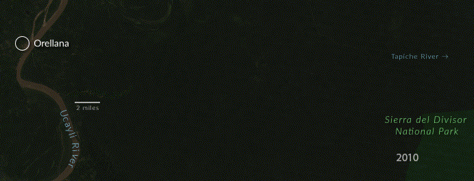
Upriver from Orellana, we stopped at a logging camp on the right bank of the Ucayali. There were barges loaded with logs and heavy machinery, in what seemed to be a permanent post (Figure 11). Multiple wooden buildings with cement floors served as living quarters, a large dining room and working space.
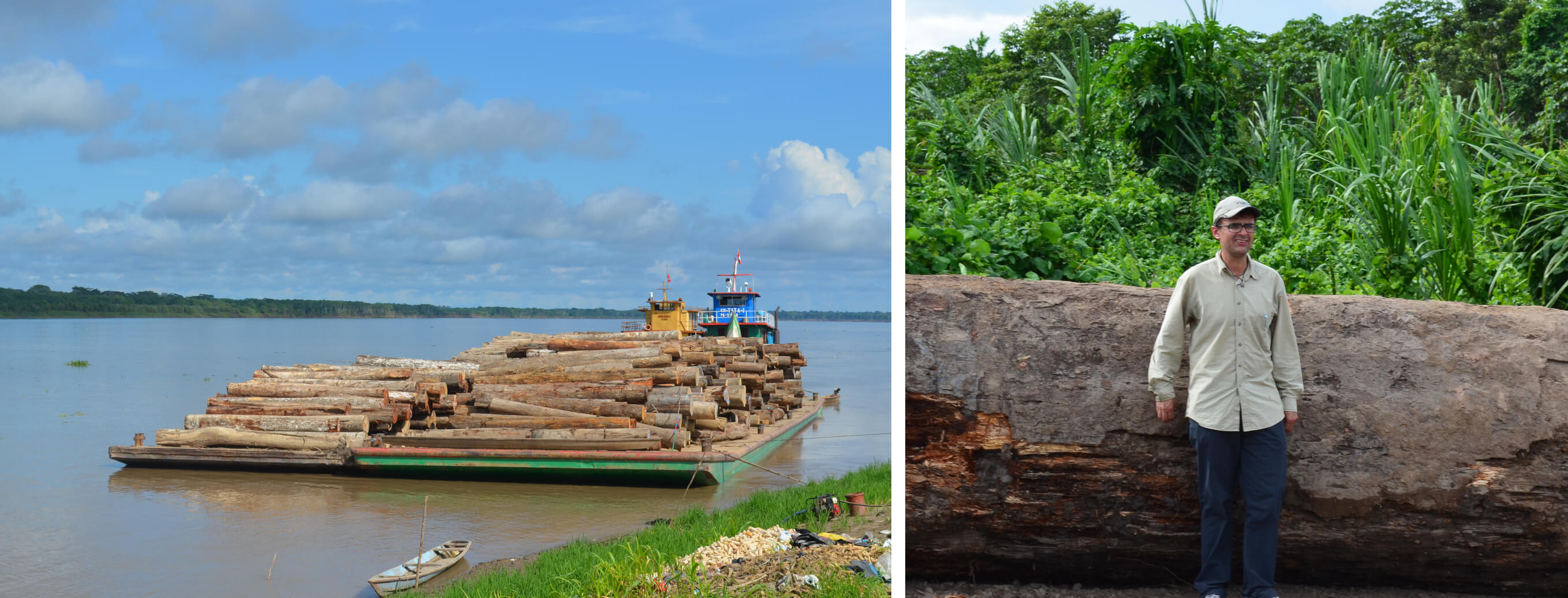
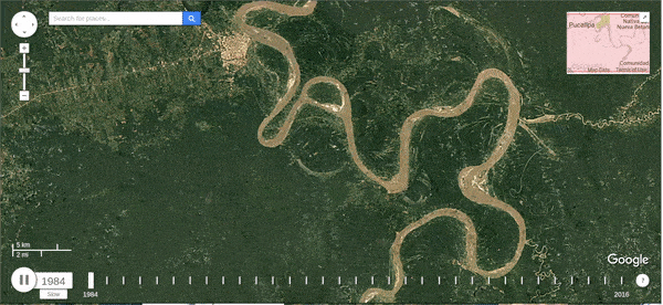
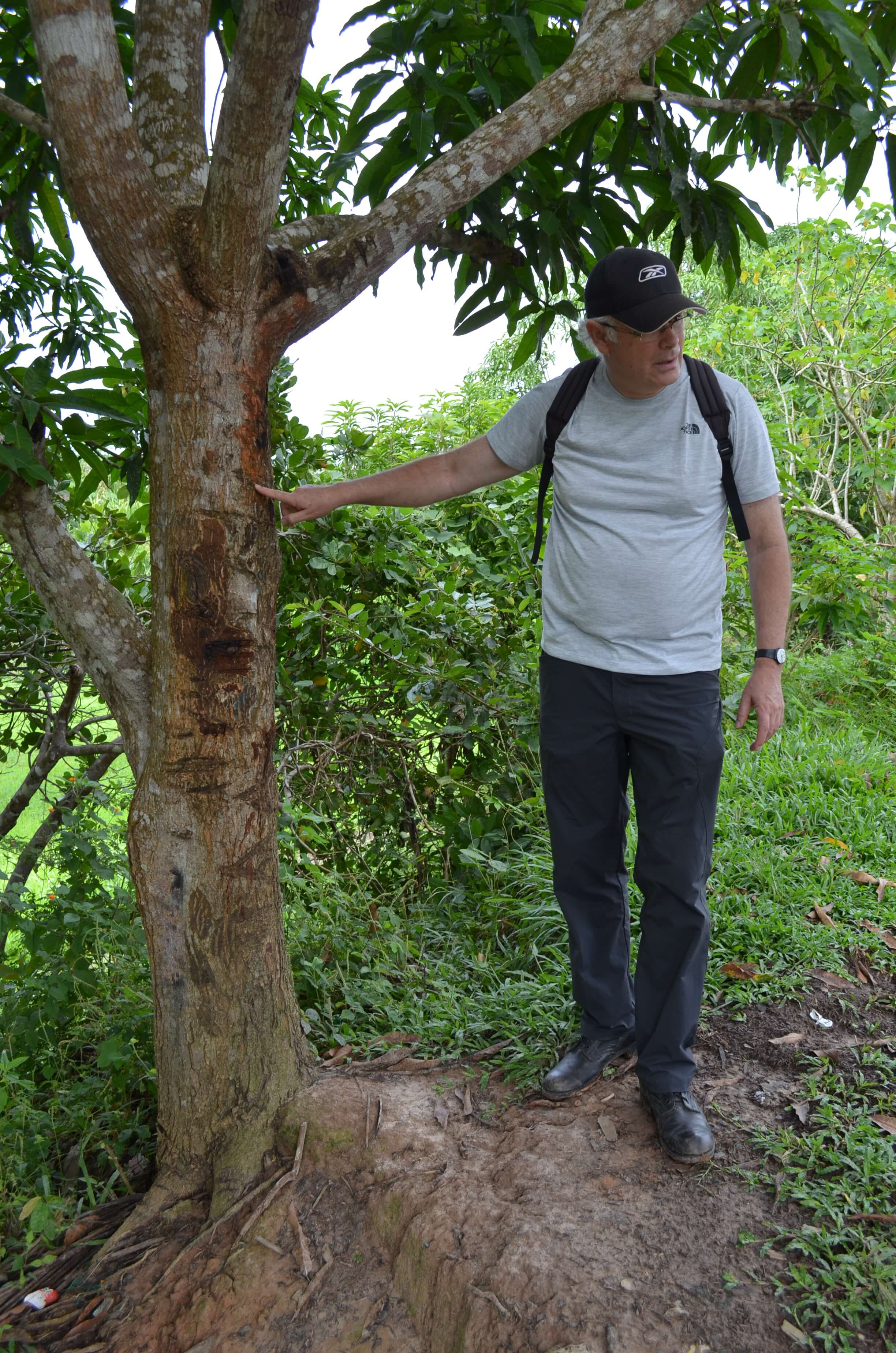
Women washing large pots greeted us as we walked by. Carlos, our guide, had suggested we stop there to see the post and to visit Isla Baños, a small community that is located 3 km inland along a road built by a Pucallpa logging company that runs the post. People from Isla Baños told us the road extends about 100 km to the east, where the company was logging. According to them, trucks hauled out logs, day and night, and the volume of timber at the site pointed to much activity. Although dusty, the road was in perfect condition, an investment indicative of the value of the resource being extracted. The road was not quite as long as people suggested, but it can easily be spotted on Google Earth, reaching eastwards almost halfway to the Tapiche River. What is most striking from the satellite imagery is how quickly the road has advanced, knowing that all valuable timber species are being stripped out (Figure 12). The Sierra del Divisor National Park lies only a few kilometers further east.
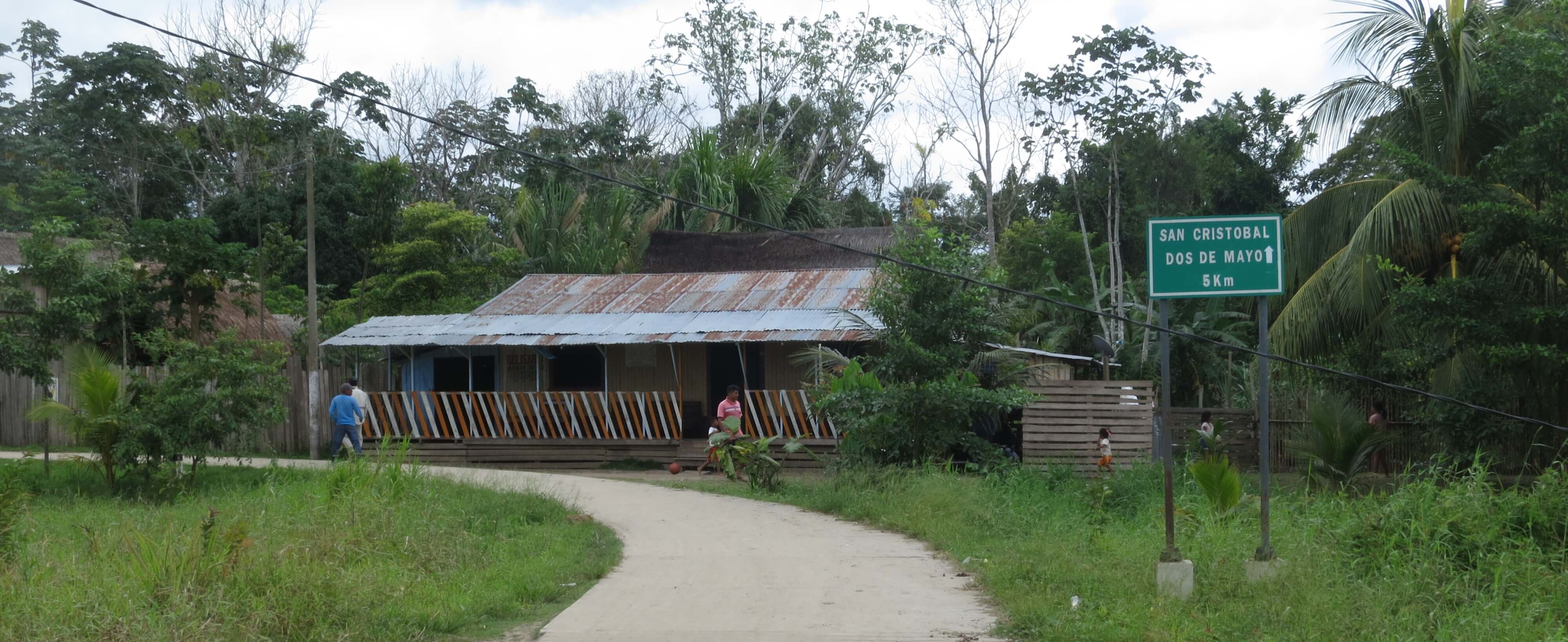
In various places along the lower Ucayali we encountered a different type of roads that connect inland communities with those at the river's edge. These rural roads are generally only a few kilometers long but bring tremendous benefits to people living in floodplain communities. One good example is the short road from Dos de Mayo — an old community that used to be at the edge of the Ucayali but was left stranded when the river migrated — to San Cristobal, located on the riverbank (Figure 13). The road, which is paved and wide enough for two rickshaws (motokars), provides a lifeline for Dosdemayinos and facilitates inter-community interactions. Unlike other roads, these roads are built not to extract resources but to connect people.
Floods are fundamental to life along the Amazon River. They replenish soils, are key for fisheries and facilitate transportation. For locals, floods are a given, and in general they are well adapted to them. Yet, floods can create significant challenges for people, especially if flood events are long, high, or come early (Langill and Abizaid 2020) or when sudden flood reversals (repiquetes) occur during the recession period (Coomes et al. 2016). Periodically, severe floods destroy crops, kill livestock, cause disease, food and income shortages, and disrupt social life (Denevan 1996; Harris 1998; Coomes 2010; Sherman et al. 2016; Langill and Abizaid 2020; Langill 2020).
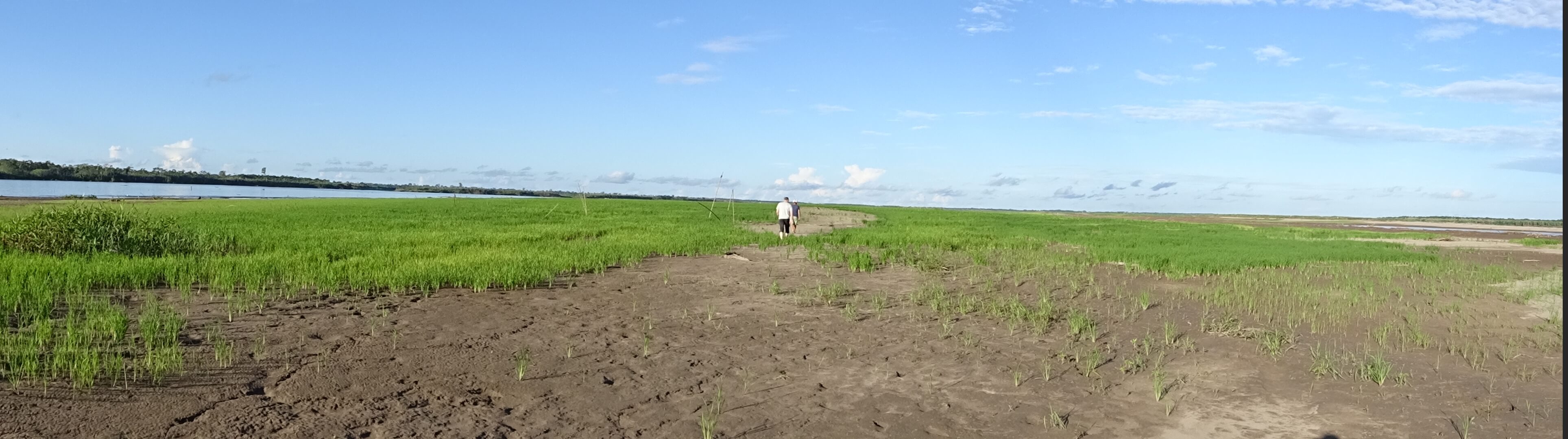
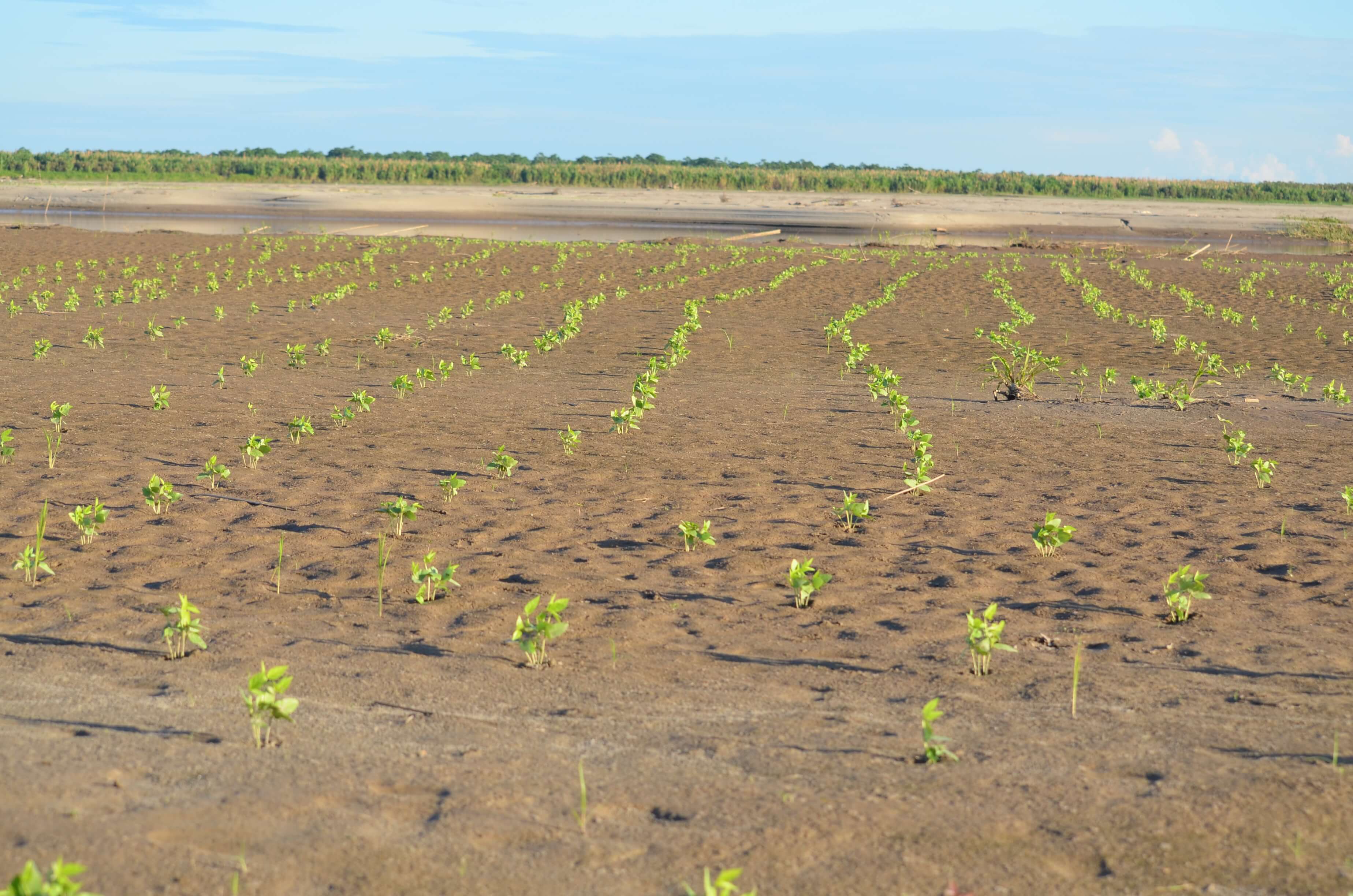
Climate change models predict higher and longer floods in western Amazonia (Sorribas et al. 2016; Ronchail et al. 2018) and with settlements concentrated along rivers, people in the Peruvian Amazon are likely to be among the first and hardest hit. How will they fare? Severe floods have been reported to occur every 3-to-6 years near Pucallpa (Langill and Abizaid 2020) and 2011 and 2014 were record-height floods (Figure 14); the risk of repiquetes affecting rice grown on mudflats is very high (60-70%), with average loss of 40% of the crop (List and Coomes 2017). A significant repiquete occurred just days before our trip (a 2.65 m spike in 48 hours; the typical annual flood amplitude is about 10 m) (DRAU, 2018). We stopped at a large mudflat planted with rice at Las Brisas, a left-bank community about 1.5 hours upstream from Contamana. The rice in the higher areas was amongst the lushest we have ever seen, but it was evident that the lower sections, closer to the river, had been severely damaged (Figure 15). A local farmer contemplating his loss said he was unsure if he would replant rice, or grow cowpeas instead, but he knew he had to plant again soon if he was to harvest before the next flood. Time will tell if mudflat rice will continue to be viable in the future.
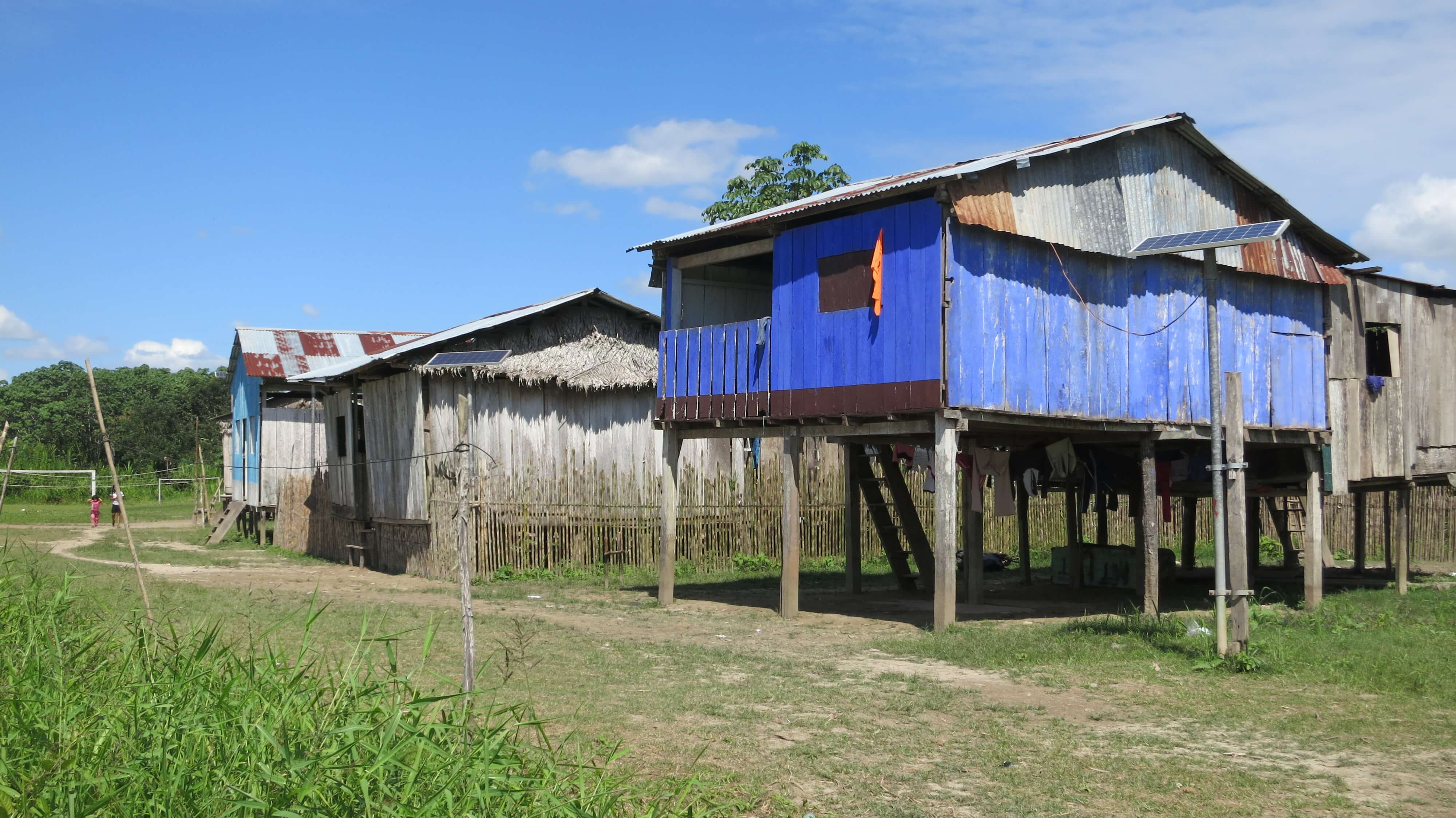
Despite intensified flooding, it is not always practical for people to resettle on higher ground, because of difficulties in access. Instead, people in many communities are raising their houses on higher stilts to ensure they stay above the flood. We saw houses standing on stilts up to 8 feet tall in places like Tacshitea and Huarmi Isla I(Figure 16), close to the mouth of the Callería and the Puinahua canal, respectively. Interestingly, in some places, people reported that nearby upland (terra firme) areas, which should not flood according to local floklore, are inundating. Although it remains unclear whether this is a recent phenomenon, what stemmed from conversations with local residents was that not all flooding is derived from turbid waters spilling over the riverbanks and that in some communities flooding is caused by the rise of the water table above ground surface in lower areas of the terra firme. This type of local flooding along whitewater rivers has yet to be studied but is likely to have important implications for soil fertility, human health, and ultimately it may challenge the upland-floodplain distinction that still dominates local folklore and academic discourse.
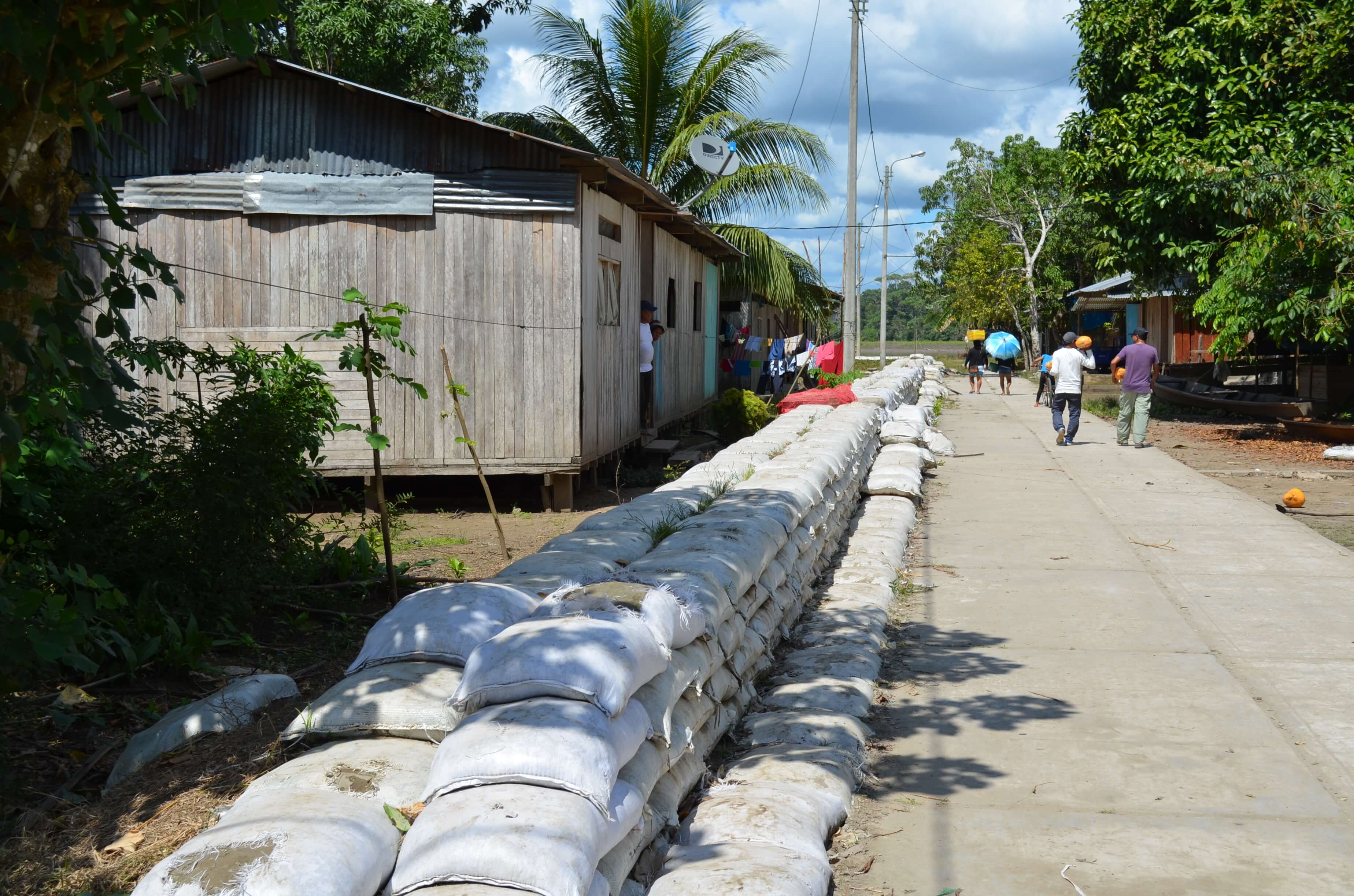
In response to severe floods in the last decade, district governments along the lower Ucayali have put hefty amounts of money to build flood protection walls around communities that may also serve as causeways during the high water (Figure 17). In Manco Capac alone, close to $300,000 were spent in 2017, mostly in wages to residents, but we saw such structures in several towns and communities in the lower reaches of the Ucayali. These walls have yet to be put to the test with a high flood, but their effectiveness at protecting communities from the water rising is questionable and thus may be giving people a false sense of security. It is possible that this initiative was geared at creating jobs, especially in leading up to an election year, rather than to protect people from floods.
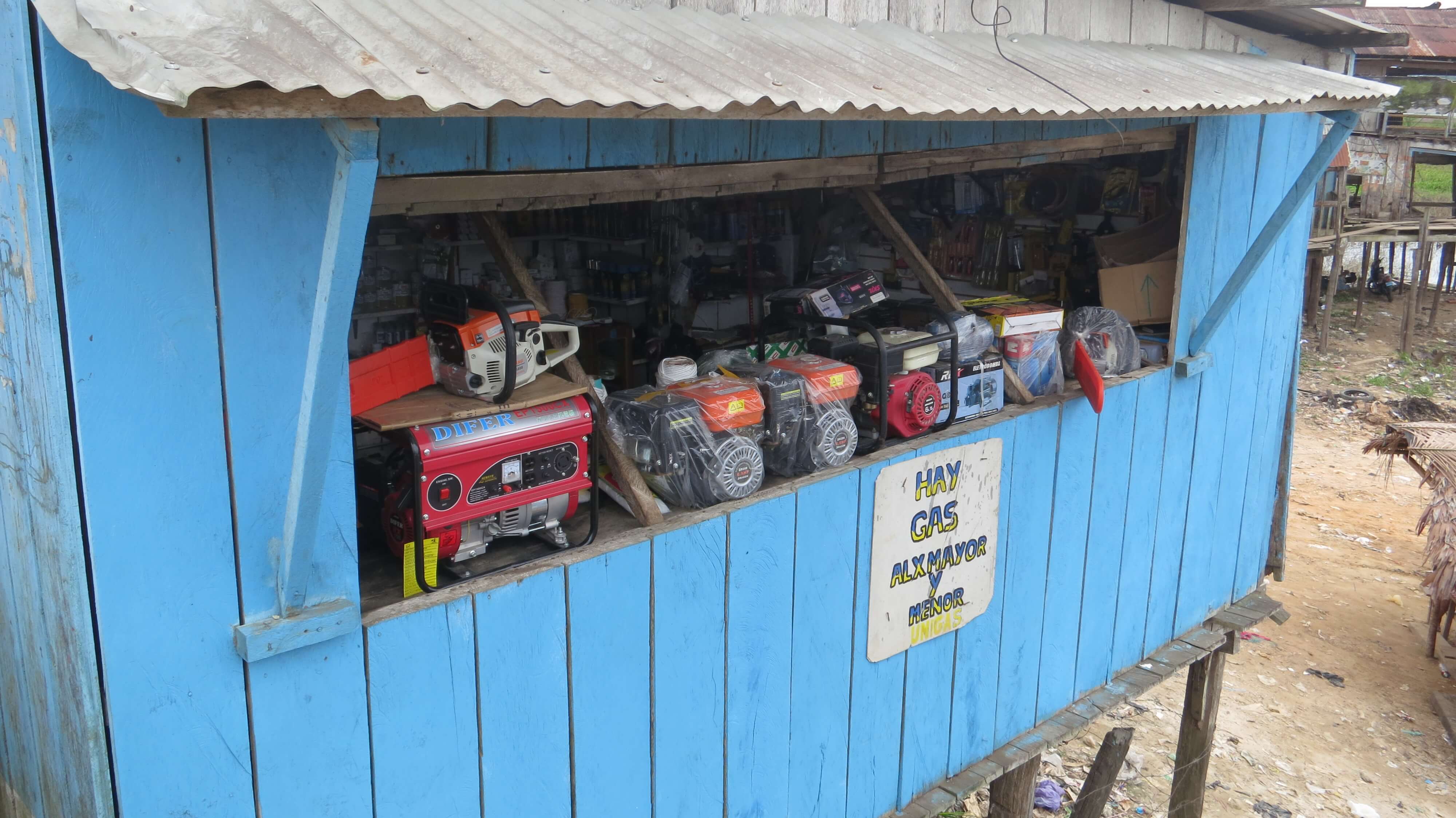
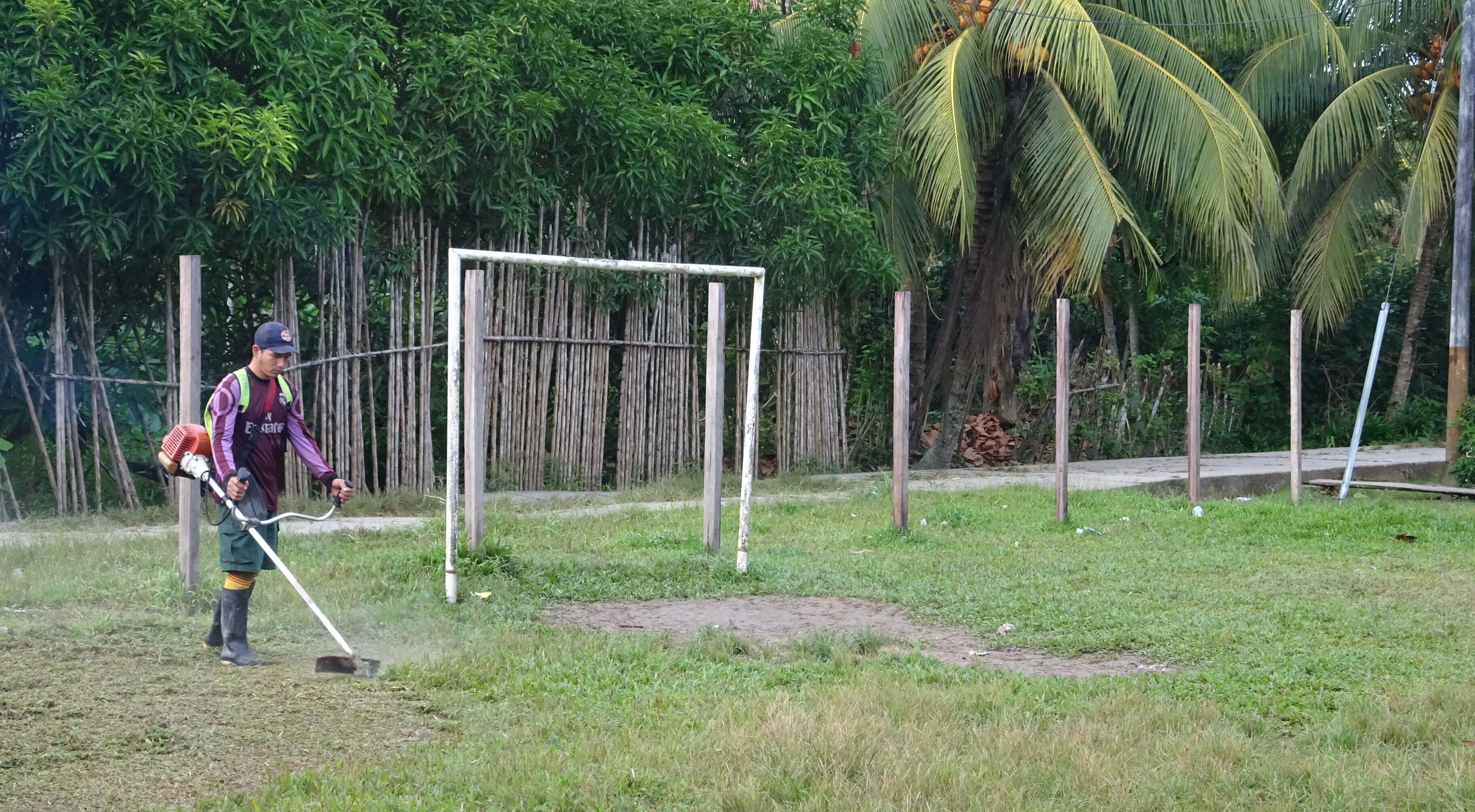
A striking trend we observed on this trip is the recent and widespread adoption of small motors and cell phones, which are changing life in the region. Small motors have been used as boat engines and in chainsaws at least since the 1960s, but only the wealthiest people could afford them, using them to run a colectivo, to fish, or for logging (Bergman 1980; Hiraoka 1985). The motors we found on our trip are as low-tech as those from the 1960s, but as a result of the 2010 China-Peru Free Trade Agreement, which removed tariffs on imports of small motors and motorized equipment, Peru has been flooded with very affordable small motors. A 5.5 hp peque-peque engine can be purchased new in Pucallpa for as little as $100, and less if second-hand; about one-fifth of the cost of a motor in the early 2000s (Figure 18). According to residents from a community close to Pucallpa, it is possible to earn enough money to buy a peque-peque from one or two good nights of fishing, or from profits from a good harvest. Another significant advantage of these motors is that they can be repaired with simple tools and limited mechanical knowledge. Beyond boats and chainsaws, small motors are widely used today to power motokars, cargo rickshaws (furgones), and rudimentary wagons locally known as Kubotas, portable sawmills, water pumps, weed-eaters, threshers, generators, among other things that are easing life for people (Figure 19). Even in small communities everyone seemed to have a peque-peque, something that was rare only 15 years ago; shop owners carry stock of gasoline and replacement parts, and some, as in San Cristobal, sold the motors locally.
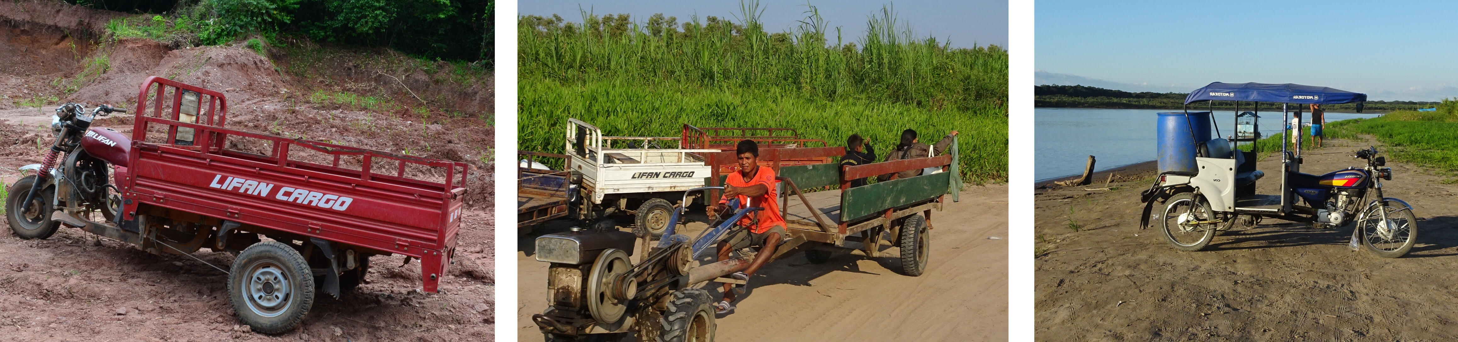
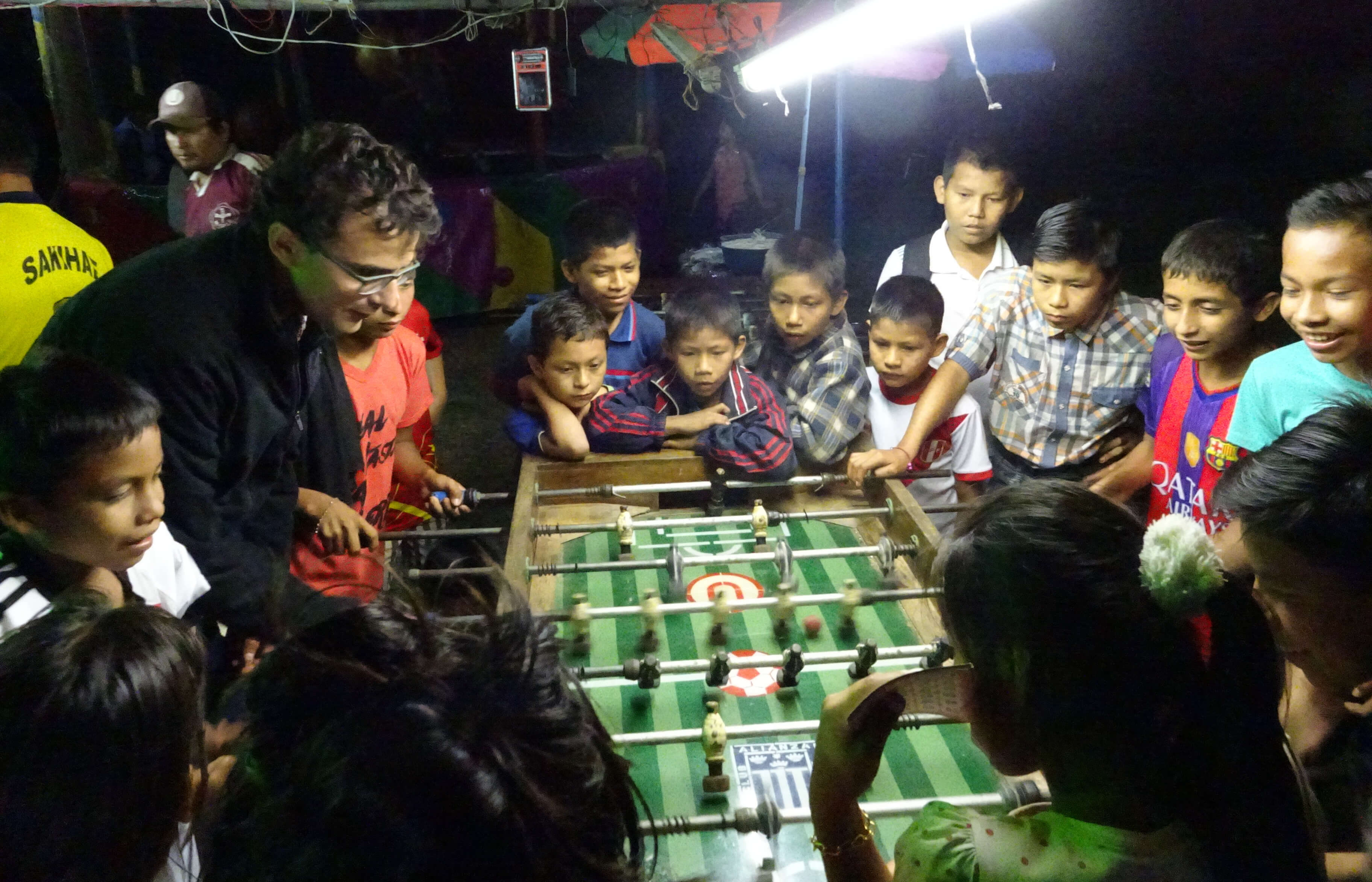
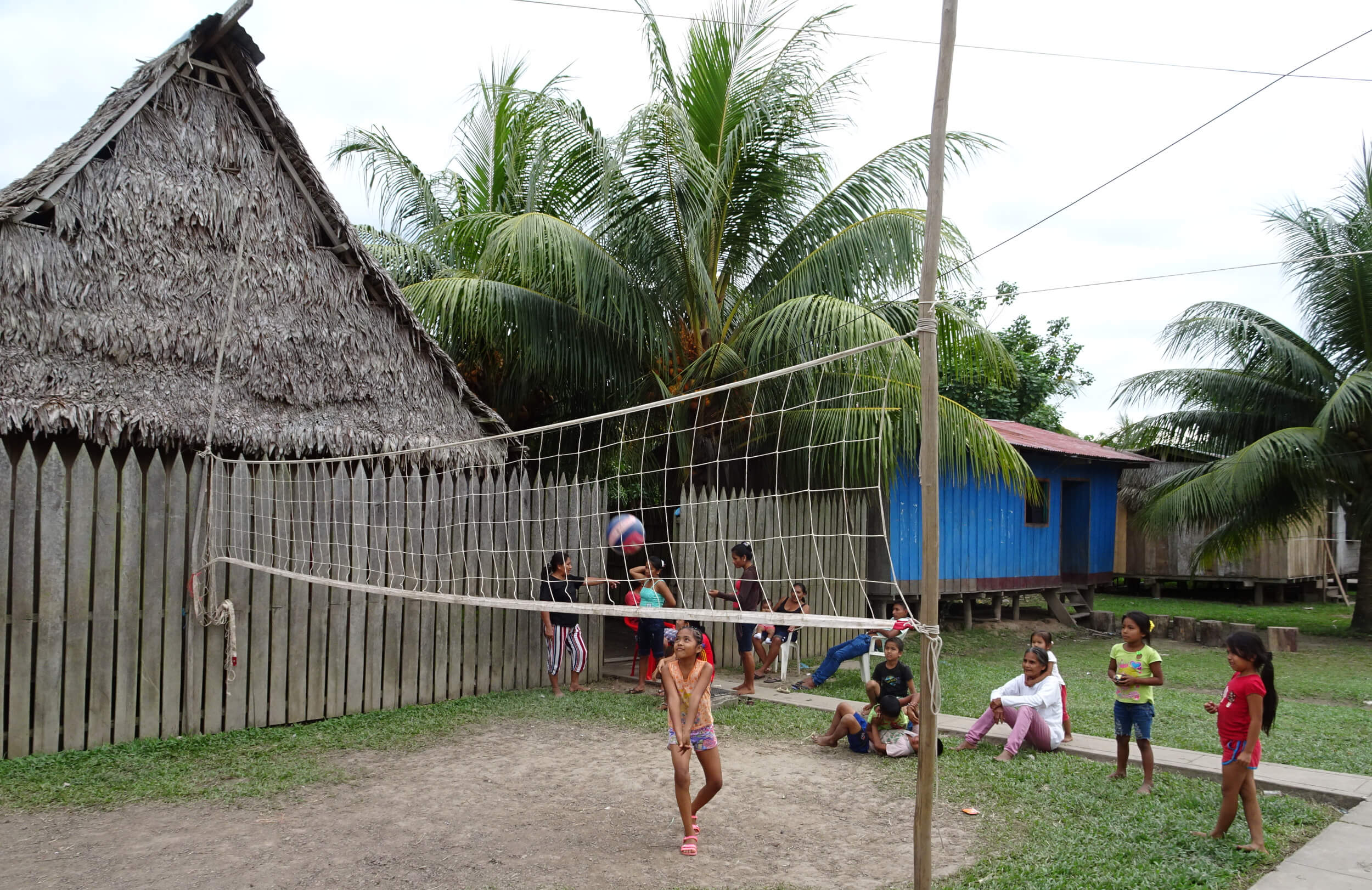
The implications of these changes for livelihoods and resource conservation are profound. People commented that a peque-peque allows them to tend fields and fish at more distant sites. Personal boats have made it much easier to travel to visit relatives and friends, to attend sports tournaments in other communities (Walker 2013; Abizaid et al. 2018), and to transport more produce to and from the market (Figure 20). Small motors are making some agricultural tasks faster and less burdensome and could change agricultural labor relations. In several communities we saw men returning from the fields, weed-eaters on their shoulder instead of a machete. In conversation, it became clear that wage labor arrangements were shifting from daily wages to task-based work due to the increased labor efficiency of weed-eaters (Figure 21). Besides easing labor bottlenecks, this shift is translating into higher earnings for some laborers. A man in Tamanco mentioned that under this arrangement, people can earn about 70 S/. in 5 hours, which is more than double the daily wage. Higher wages could create disincentives to participate in cooperative labor parties (mingas) and community public works, which are important to social life in rural Amazonia (Hames 1987; Chibnik and de Jong 1987; Abizaid et al. 2015). We were unable to confirm the situation about mingas, but local residents did tell us that people are more likely to participate in public works such as the clearing of streets or weeding around the school, because working with weeders is faster and much less onerous than working with machetes.
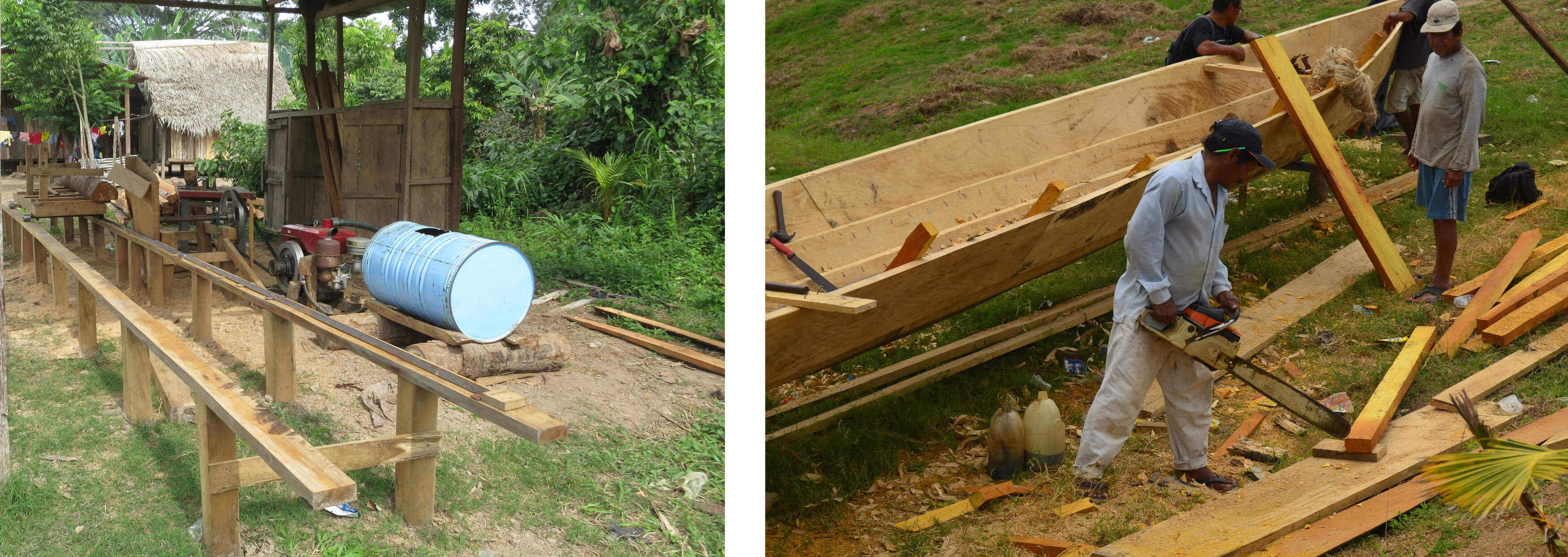
More broadly, small motors are creating new economic opportunities for rural peoples, allowing them to add value locally, provide new services, and run different types of businesses. We saw, for instance, a portable sawmill in Nuevo Canchahuaya and a group of men using a chainsaw to build a boat in Alto Perillo (Figure 22). We consistently encountered motokars, furgones and Kubotas transporting people or cargo in and around communities. In Victoria there were two sewing shops where women were making school uniforms and soccer jerseys of the Peruvian National team as part of the World Cup craze, using textiles brought in from Lima. Clearly, this diversification has the potential to exacerbate inequalities and social differentiation. However, the affordability of the smaller motors, especially peque-peques, also lowers entry barriers for participation in some activities. For instance, with a small peque-peque anyone can run a boat taxi (llevo-llevo) (Langill 2020), and in combination with an old fridge and ice, fishermen can preserve their fish longer and take their catch directly to market for sale (Figure 20) (Poissant 2021).
Like motors, cell phones have gained much popularity in the Peruvian Amazon, despite lagging coverage relative to other regions of Peru. Over the last few years and as part of an agreement with the Peruvian Government, Telefónica del Peru has established a network of small antennae in selected rural communities that have been a game changer for rural populations along the middle and lower Ucayali in general (Andina 2016). Cell phones have provided valuable communication during the COVID-19 pandemic; with rural (fixed) phones inactive since 2019, cell phones have been the primary source of communication during the current pandemic (Takasaki et al. 2021). Claro, a subsidiary of Carlos Slim's TelMex and the second main carrier in Peru, tends to focus on urban coverage. It was interesting to find that cell phone access was ubiquitous, and that young people are just as obsessed with cell phones as those in Lima or North America. Locals use phones to talk with relatives and friends and some are quite active in social media, but most importantly for our work, we found that people of the Ucayali are also using cell phones to get market and price information, to connect with buyers in market towns and to coordinate transportation services. For example, at a community near the Pacaya-Samiria National Reserve (PSNR), a local shop owner was not shy to ask if we were interested in buying turtle eggs, a sale that would be illegal. He said he could get them for us once the turtles laid their eggs and could give a buzz over a cell phone to coordinate the shipment and payment. Similarly, a local informal lender (habilitador) for fish in the same community told us that thanks to her cell phone, she has been able to bypass intermediaries in the city and is now selling fish directly through a relative based in Pucallpa.
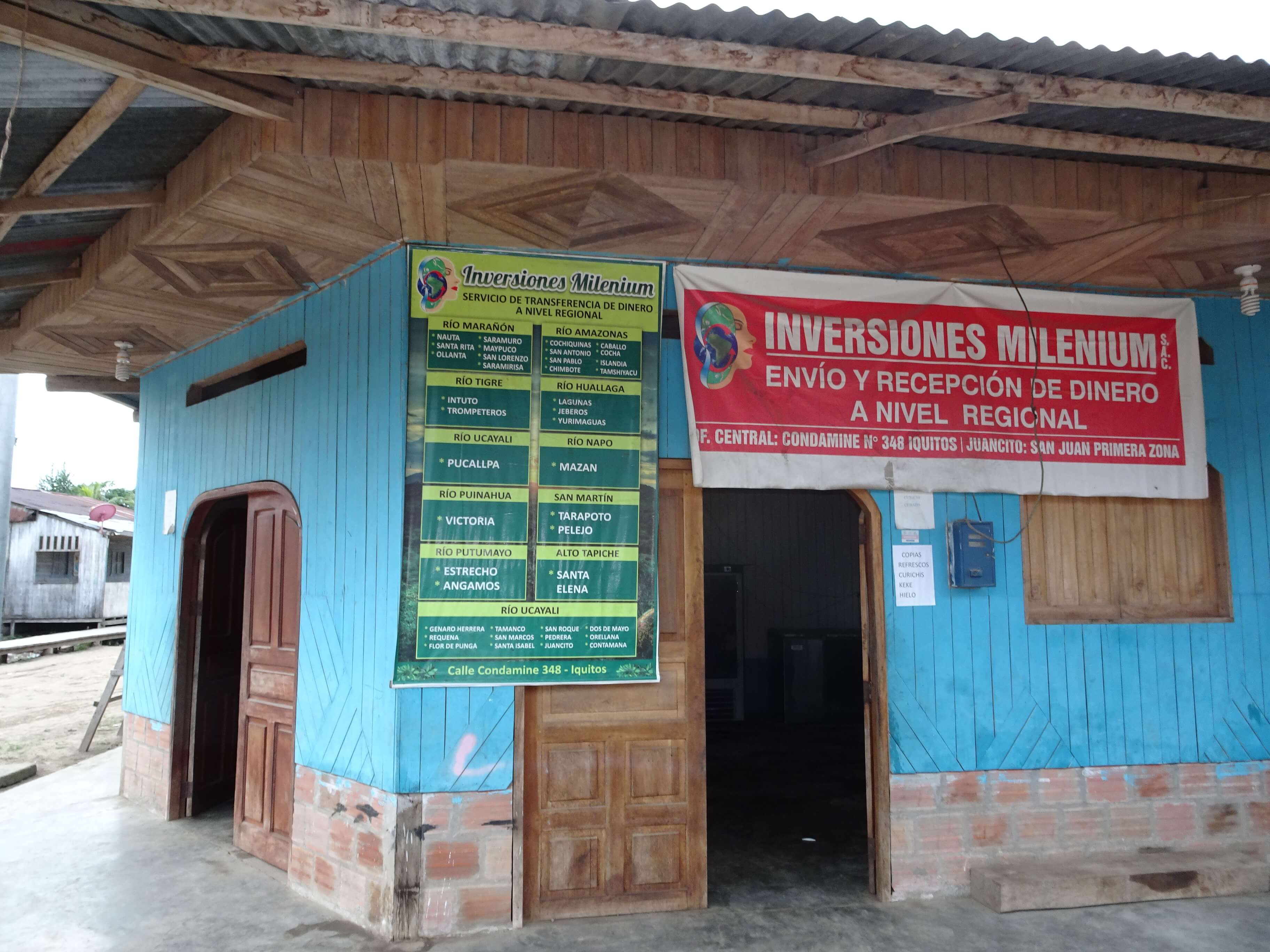
But most striking for us was to find an emergent money transfer scheme linked to cell phones. In a region where cash is scarce, it seemed unimaginable that we would encounter ads posted outside of stores, offering quick, safe and reliable money transfers within Loreto, Ucayali and San Martín, as we walked the streets in small towns such as Bretaña, Juancito, San Roque and Victoria, among others (Figure 23). At least five companies were offering such services, one of them covering more than 40 communities and towns in Loreto alone. We learnt about how the service works from Don José (pseudonym), a local contact in Bretaña, close to the PSNR and the site of a recent violent confrontation with police forces after the occupation of an oil facility by local indigenous peoples (Fernández Calvo 2020). According to Don José, someone wishing to send money would come to him with the desired amount to transfer and the name and location of the receiver. He would then contact a partner merchant in the destination community (or a central office) using his cell phone, with the instruction to pay out the money to that person al toque (on the spot), charging 10 S/. ($4) for transfers of up to 1000 S/. ($400). Like Western Union, this type of service is likely important for transferring remittances but given its less formal nature there is concern that it could be used for money laundering and to finance illegal activities. Based on our conversations with locals, we think habilitadores in the city may use these cellphone-based money transfers to finance extractive activities by rural households at scales unseen before.
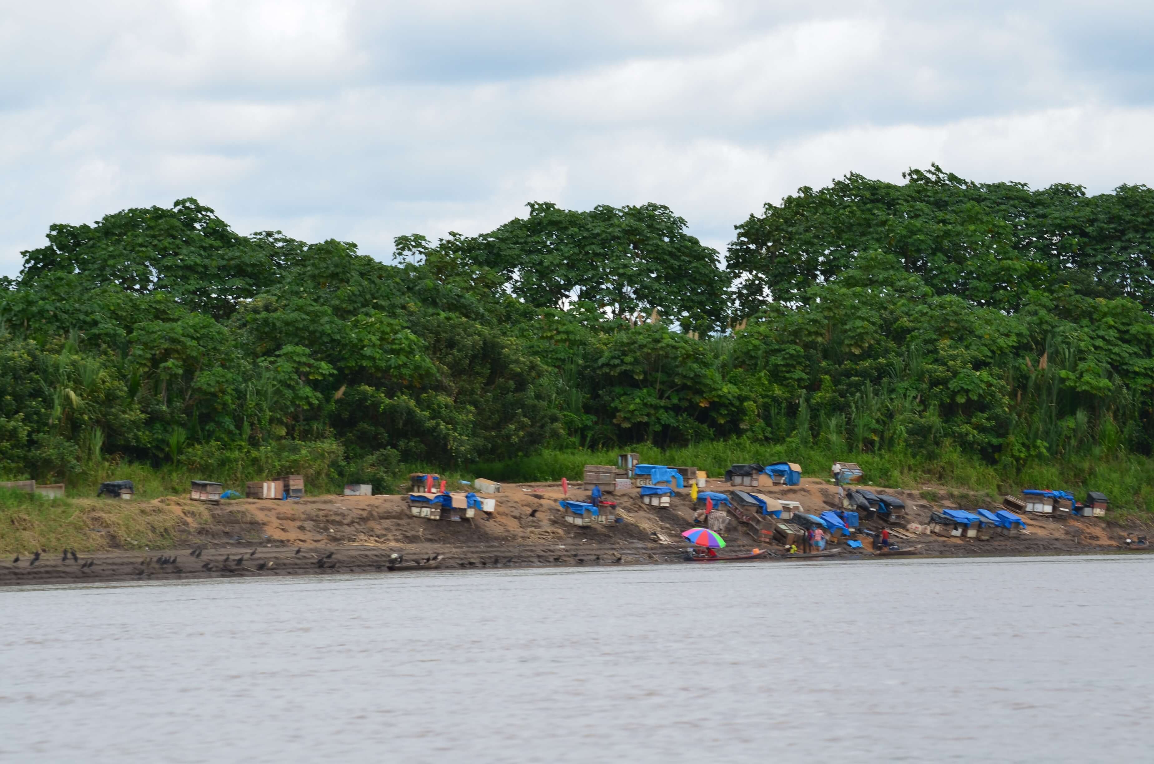
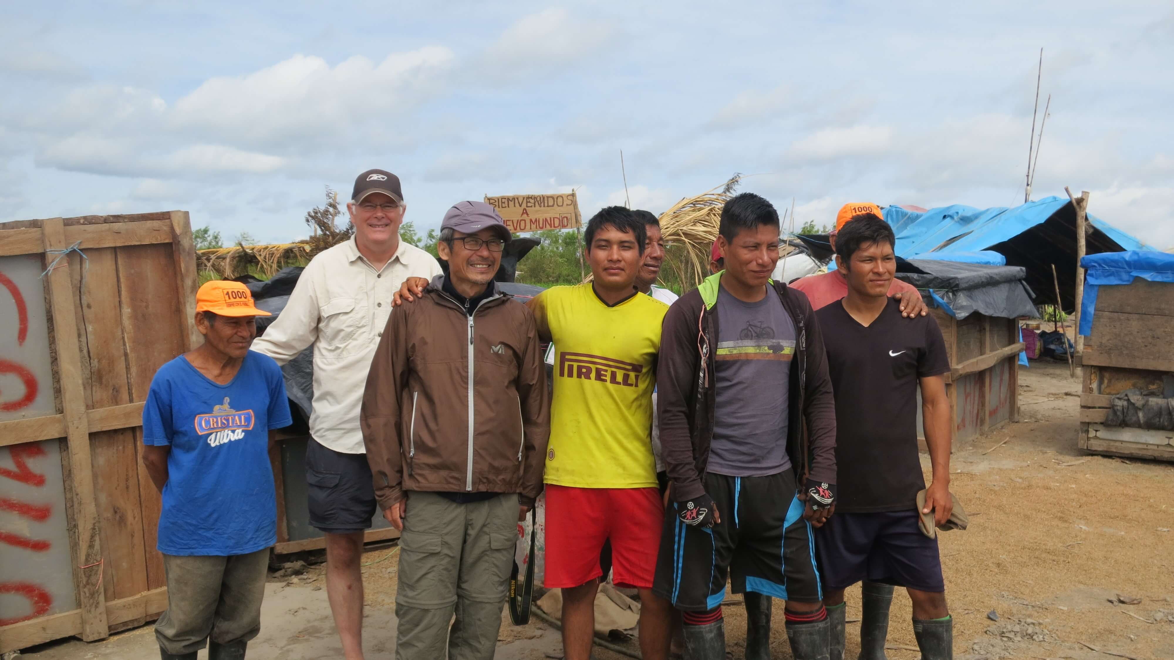
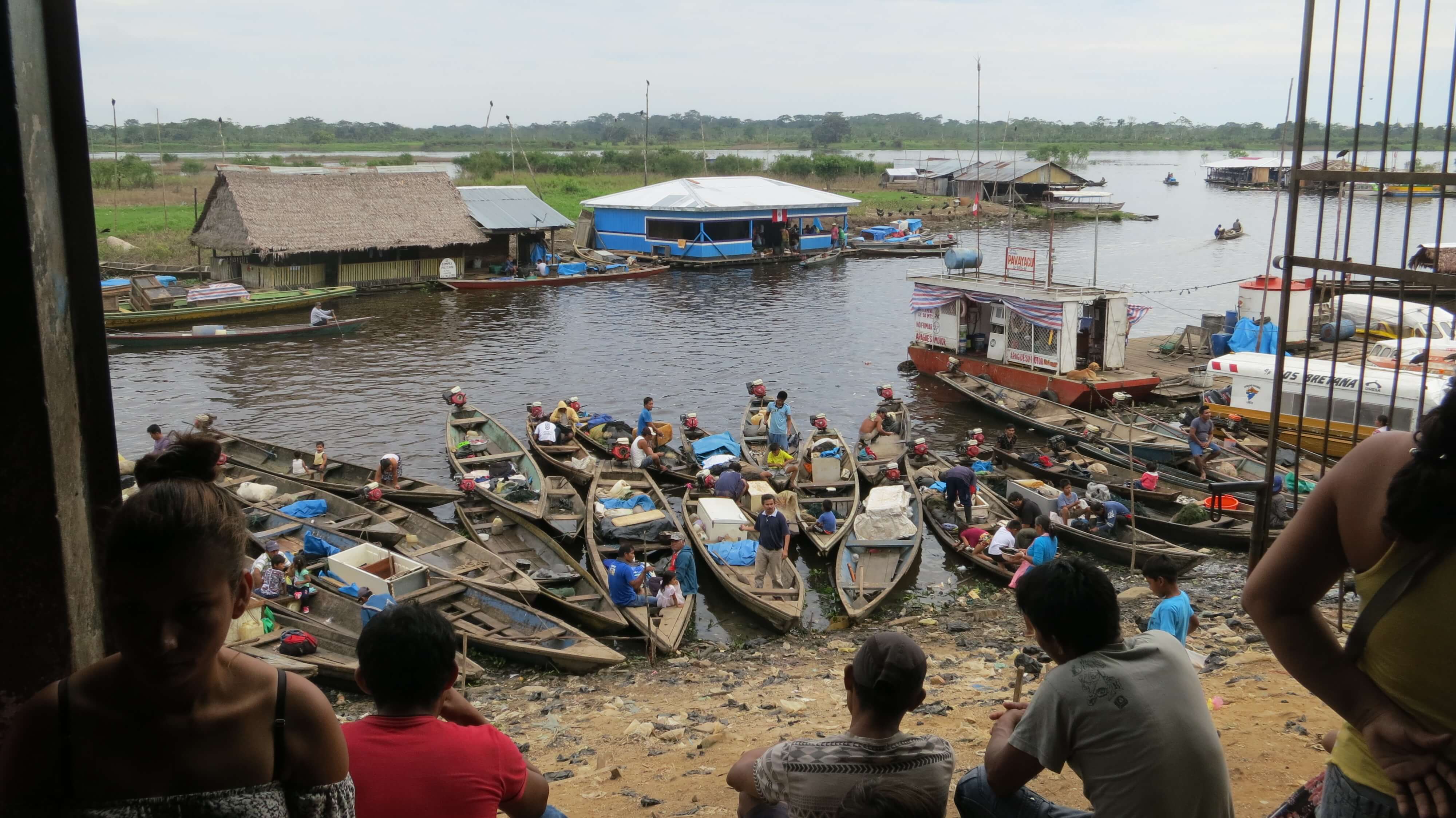
Some 50 kilometers downstream from where the Puinahua canal starts, a series of fishing camps along the shores of the Ucayali (Figure 24) caught our attention so we decided to stop at one to talk to the fishing party. They were from Nueva York— not the Big Apple, but a small community along the Tapiche River—and were on an expedition to chase schools of migrating fish (mijanos) on the Ucayali as water levels drop. Backing a sign that said in Spanish “Welcome to the New World” and equipped with food for about a month, fishing supplies (boats, nets, gasoline, ice, salt and old fridges as ice boxes), these fishermen told us they were waiting for the fish to leave three nearby oxbow lakes and, armed with gill nets of different sizes, they hoped to catch about 10 tonnes of fish in just days (Figure 25). We did not have an opportunity to ask them about how they procured their supplies, but it is not difficult to envision how money transfer services through cell phones could be mobilized to finance ventures like this or even larger ones. Back in Bretaña, Belisario (pseudonym), who drove us around in his motokar, explained that on the side, he buys fish to freeze and send to the city. He coordinates in advance with a stable pool of clients who transfer him the money once the fish have been sold. Cell phones are reducing the cost of transactions and are changing lives along the river in significant ways.
Peru holds the second largest area of the Amazon basin, yet it is far less well known than the Brazilian Amazon. Our 1000 km boat journey down the Ucayali opened our eyes to important changes underway in the Peruvian Amazon. Changes in river transport mobility, new roads, hydrological changes due to climate change, and the arrival of small motors and cell phones are rapidly changing the environment and lives and lifeways of the people who live along one of the largest tributaries of the Amazon River. Our observations and conversations with people as we travelled down the Ucayali on the Carlitos suggest that the Ucayali River is shaping up as one of the most dynamic frontiers in Amazonia, especially along the west bank of the Ucayali, as a key region for Andes-Amazon integration. Although the changes we report on in this article are important individually, their combined synergistic effects will be greater. Although the Peruvian Amazon remains still largely undeveloped, our findings from this boat trip provide a glimpse into greater changes to come to the region and lend support to concerns that change in western Amazonia may follow in the footsteps of Brazil. How will the environment and the people of the Ucayali and the Peruvian Amazon fare in the coming years remains to be discovered.

We are grateful to Carlos Rengifo (our guide) and Orison Tapayuri (boat pilot) without whom the trip would have not been possible. We are most thankful to all the people of the Ucayali we encountered along the journey for their warmth and generosity; they made the trip so much more interesting and enjoyable. The map was prepared by Julia Daley and Helen Turvene. An earlier version of this article was presented at the 2020 Meeting of the Conference of Latin American Geography in Antigua, Guatemala. We also thank Michael Steinberg and two anonymous reviewers for their thoughtful comments which helped us to improve this article. The trip was supported by grants from the Japan Society for the Promotion of Science (JSPS) (18KK0042, 18H05312, 26245032) and the Social Science and Humanities Research Council (SSHRC) of Canada (435-2015-145 0520; 430-2016-00974). We dedicate this article to the riverine populations of Ucayali and Loreto in Peru, with whom we have had the privilege to work with over the years.